
Page 81 - Hydrogeology Principles and Practice
P. 81
HYDC02 12/5/05 5:38 PM Page 64
64 Chapter Two
where the Cretaceous Chalk, Permo-Triassic sand- surface water sources, the Precambrian and Pala-
stones and the Jurassic limestones contribute one- eozoic rocks in the remoter areas of Ireland, Scotland
third of abstracted water supplies, of which half is and Wales have sufficient storage to be of local im-
reliant on the Chalk aquifer. Unlike many other coun- portance for domestic supplies and in supporting
tries, these important water supplies are dependent baseflows to minor rivers.
on fissure flow in making the limestones and sand- The hydrogeology of England and Wales, Scot-
stones permeable. Aquifers also exist in the older land and Northern Ireland is presented in a number
rocks such as the Carboniferous limestones and in of maps produced by the Institute of Geological
more recent formations such as the Pleistocene sands Sciences (1977) and the British Geological Survey
and gravels, but these aquifers are not of such (1988, 1994), respectively, with the hydrogeology of
regional significance. Although less important than Scotland documented in a memoir (Robins 1990). In
BO X
Large-scale groundwater flow in the Great Artesian Basin, Australia
2.11
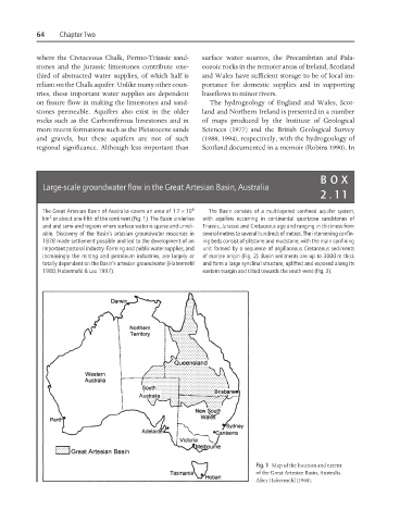
The Great Artesian Basin of Australia covers an area of 1.7 × 10 6 The Basin consists of a multilayered confined aquifer system,
2
km or about one-fifth of the continent (Fig. 1). The Basin underlies with aquifers occurring in continental quartzose sandstones of
arid and semi-arid regions where surface water is sparse and unreli- Triassic, Jurassic and Cretaceous age and ranging in thickness from
able. Discovery of the Basin’s artesian groundwater resources in several metres to several hundreds of metres. The intervening confin-
1878 made settlement possible and led to the development of an ing beds consist of siltstone and mudstone, with the main confining
important pastoral industry. Farming and public water supplies, and unit formed by a sequence of argillaceous Cretaceous sediments
increasingly the mining and petroleum industries, are largely or of marine origin (Fig. 2). Basin sediments are up to 3000 m thick
totally dependent on the Basin’s artesian groundwater (Habermehl and form a large synclinal structure, uplifted and exposed along its
1980; Habermehl & Lau 1997). eastern margin and tilted towards the south-west (Fig. 3).
Fig. 1 Map of the location and extent
of the Great Artesian Basin, Australia.
After Habermehl (1980).