
Page 85 - Hydrogeology Principles and Practice
P. 85
HYDC02 12/5/05 5:38 PM Page 68
68 Chapter Two
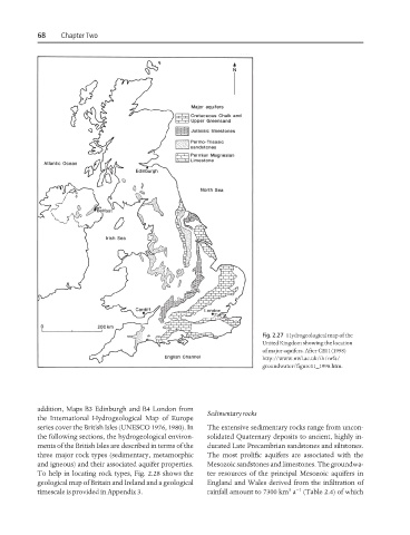
Fig. 2.27 Hydrogeological map of the
United Kingdom showing the location
of major aquifers. After CEH (1998)
http://www.nwl.ac.uk/ih/nrfa/
groundwater/figure11_1998.htm.
addition, Maps B3 Edinburgh and B4 London from
Sedimentary rocks
the International Hydrogeological Map of Europe
series cover the British Isles (UNESCO 1976, 1980). In The extensive sedimentary rocks range from uncon-
the following sections, the hydrogeological environ- solidated Quaternary deposits to ancient, highly in-
ments of the British Isles are described in terms of the durated Late Precambrian sandstones and siltstones.
three major rock types (sedimentary, metamorphic The most prolific aquifers are associated with the
and igneous) and their associated aquifer properties. Mesozoic sandstones and limestones. The groundwa-
To help in locating rock types, Fig. 2.28 shows the ter resources of the principal Mesozoic aquifers in
geological map of Britain and Ireland and a geological England and Wales derived from the infiltration of
3 −1
timescale is provided in Appendix 3. rainfall amount to 7300 km a (Table 2.4) of which