
Page 86 - Hydrogeology Principles and Practice
P. 86
HYDC02 12/5/05 5:38 PM Page 69
Physical hydrogeology 69
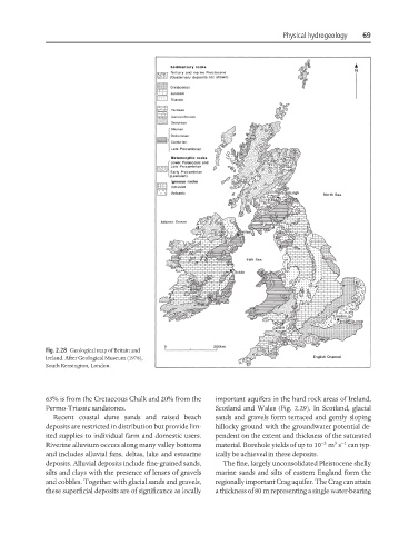
Fig. 2.28 Geological map of Britain and
Ireland. After Geological Museum (1978),
South Kensington, London.
63% is from the Cretaceous Chalk and 20% from the important aquifers in the hard rock areas of Ireland,
Permo-Triassic sandstones. Scotland and Wales (Fig. 2.29). In Scotland, glacial
Recent coastal dune sands and raised beach sands and gravels form terraced and gently sloping
deposits are restricted in distribution but provide lim- hillocky ground with the groundwater potential de-
ited supplies to individual farm and domestic users. pendent on the extent and thickness of the saturated
3 −1
−2
Riverine alluvium occurs along many valley bottoms material. Borehole yields of up to 10 m s can typ-
and includes alluvial fans, deltas, lake and estuarine ically be achieved in these deposits.
deposits. Alluvial deposits include fine-grained sands, The fine, largely unconsolidated Pleistocene shelly
silts and clays with the presence of lenses of gravels marine sands and silts of eastern England form the
and cobbles. Together with glacial sands and gravels, regionally important Crag aquifer. The Crag can attain
these superficial deposits are of significance as locally a thickness of 80 m representing a single water-bearing