
Page 88 - Hydrogeology Principles and Practice
P. 88
HYDC02 12/5/05 5:38 PM Page 71
Physical hydrogeology 71
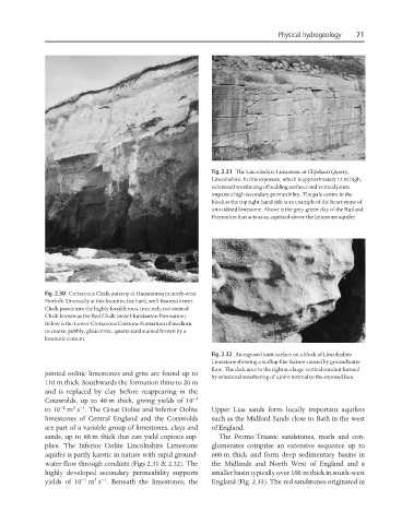
Fig. 2.31 The Lincolnshire Limestone at Clipsham Quarry,
Lincolnshire. In this exposure, which is approximately 12 m high,
solutional weathering of bedding surfaces and vertical joints
imparts a high secondary permeability. The pale centre in the
block at the top right-hand side is an example of the heart stone of
unoxidized limestone. Above is the grey-green clay of the Rutland
Formation that acts as an aquitard above the limestone aquifer.
Fig. 2.30 Cretaceous Chalk outcrop at Hunstanton in north-west
Norfolk. Unusually at this location, the hard, well-fissured lower
Chalk passes into the highly fossiliferous, iron-rich, red-stained
Chalk known as the Red Chalk (now Hunstanton Formation).
Below is the Lower Cretaceous Carstone Formation of medium
to coarse, pebbly, glauconitic, quartz sand stained brown by a
limonitic cement.
Fig. 2.32 An exposed joint surface on a block of Lincolnshire
Limestone showing a scallop-like feature caused by groundwater
flow. The dark area to the right is a large vertical conduit formed
jointed oolitic limestones and grits are found up to
by solutional weathering of a joint normal to the exposed face.
110 m thick. Southwards the formation thins to 20 m
and is replaced by clay before reappearing in the
Cotswolds, up to 40 m thick, giving yields of 10 −3
−2
3 −1
to 10 m s . The Great Oolite and Inferior Oolite Upper Lias sands form locally important aquifers
limestones of Central England and the Cotswolds such as the Midford Sands close to Bath in the west
are part of a variable group of limestones, clays and of England.
sands, up to 60 m thick that can yield copious sup- The Permo-Triassic sandstones, marls and con-
plies. The Inferior Oolite Lincolnshire Limestone glomerates comprise an extensive sequence up to
aquifer is partly karstic in nature with rapid ground- 600 m thick and form deep sedimentary basins in
water flow through conduits (Figs 2.31 & 2.32). The the Midlands and North West of England and a
highly developed secondary permeability supports smaller basin typically over 100 m thick in south-west
3 −1
−1
yields of 10 m s . Beneath the limestones, the England (Fig. 2.33). The red sandstones originated in