
Page 197 - Integrated Wireless Propagation Models
P. 197
I
M a c r o c e I P r e d i c t i o n M o d e I s - P a r t 2 : P o i n t - t o - P o i n t M o d e I s 175
3.4 Longley-Rice Model
In the 1960s, Longley and Rice introduced the Langley-Rice model, which is used
mainly for predicting the signal strength over a longer distance, says 10 mi or more. The
Langley-Rice model is a well-established, general-purpose propagation model. Basi
cally, this model presents methods for calculating the median transmission loss relative
to the free space transmission loss based on the characteristics of the propagation path.
The Langley-Rice model is essentially a computer implementation of many tech
niques described in Ref. 32. This model uses terrain information to compute terrain
roughness and radio horizons automatically. The users must supply other environmen
tal variables, such as average climate conditions, soil conductivity, and so on. While
these factors can be set to custom values, the program includes default or average val
ues that are applicable in most cases.
In this section, we merely introduce the program with associated formulas of the
Langley-Rice model. The reader can search for details from the reference.32
3.4.1 Point-to-Point Model Prediction
When a detailed terrain path profile is available, the path-specific parameters can be easily
determined, and the prediction is called a point-to-point model prediction. This prediction
tool is often applied in computer program and for a range usually over 10 miles. The method
is applicable for radio frequencies above 20 MHz. The point-to-point prediction procedure
requires detailed terrain profiles. From the profiles, one must determine the distance to the
respective radio horizon, the horizon elevation angles, and effective antenna heights. These
distances, angles, and heights are then supplied as input to the computer program.
3.4.2 Area Model Prediction
If the terrain path profile is not available in the area of interest, the Langley-Rice method
provides techniques to estimate the path-specific parameters, and such a prediction is
called an area model prediction. This model predicts a long-term median transmission
loss based on random paths made in an area where variations in terrain elevation exist.
Estimates of variability are provided as the program output. These estimates vary with
respect to location and time.
The ranges of system parameters over which the models are applicable are the
following:
1. Transmission frequency (MHz): 20 to 20,000
2. Range (km): 1 to 2000
3. Antenna heights (m): 0.5 to 3000
4. Antenna polarization: vertical or horizontal
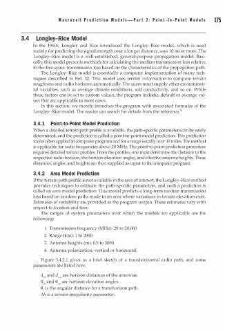
Figure 3.4.2.1 gives us a brief sketch of a transhorizontal radio path, and some
parameters are listed here:
d Lb and d Lm are horizon distances of the antennas.
eeb and eem are horizon elevation angles.
ee is the angular distance for a transhorizon path.
�h is a terrain irregularity parameter.