
Page 295 - Laboratory Manual in Physical Geology
P. 295
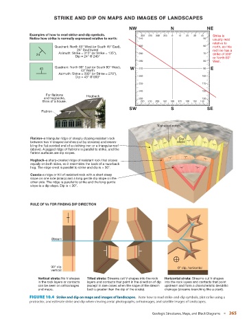
STRIKE AND DIP ON MAPS AND IMAGES OF LANDSCAPES

                                                                NW                  N                 NE
               Examples of how to read strike-and-dip symbols.        320  330  340  350  0  10  20  30  40  Strike is
               Notice how strike is normally expressed relative to north:  310                      50   usually read
                                                                                                         relative to
                            Quadrant: North 45° West (or South 45° East),  300                      60   north, so this
                                       24° Southwest                                                     red line has a
                              Azimuth: Strike = 315° (or Strike = 135°),  290                       70
                   24                                                                                    strike of 300°
                                      Dip = 24° @ 245°
                                                                                                         or North 60°
                                                                     280                            80   West.
                            Quadrant: North 90° East (or South 90° West),
                    43                                          W    270                            90  E
                                        43° North
                              Azimuth: Strike = 090° (or Strike = 270°),
                                      Dip = 43° @ 000°               260                           100
                                                                     250                           110
                                                                     240                           120
                       For flatirons       Hogback
                      and hogbacks,                                  230                           130
                      think of a house.                              220  210  200  190  180  170  160  150  140
                                                                SW                  S                 SE
                     Flatiron


                                                                              V-shaped notch

                Flatiron–a triangular ridge of steeply dipping resistant rock            Dip
                between two V-shaped notches (cut by streams) and resem-               slope
                bling the flat pointed end of a clothing iron or a triangular roof
                (above). A jagged ridge of flatirons is parallel to strike, and the
                flatiron surfaces are dip slopes.
                Hogback–a sharp-crested ridge of resistant rock that slopes
                equally on both sides, so it resembles the back of a razorback
                hog. The ridge crest is parallel to strike and dip is > 30°.

                Cuesta–a ridge or hill of resistant rock with a short steep
                slope on one side (scarp) and a long gentle dip slope on the
                other side. The ridge is parallel to strike and the long gentle
                slope is a dip slope. Dip is < 30°.


                RULE OF Vs FOR FINDING DIP DIRECTION


                          Stream


                          90° dip                                                       0° dip, horizontal
                          vertical
                    Vertical strata: No V-shapes   Tilted strata: Streams cut V-shapes into the rock   Horizontal strata: Streams cut V-shapes
                    in the rock layers or contacts   layers and contacts that point in the direction of dip  into the rock layers and contacts that point
                    can be seen on orthoimages   (except in rare cases when the slope of the stream   upstream and form a characteristic dendritic
                    and maps.              bed is greater than the dip of the strata).  drainage (streams branching like a plant).

                 FIGURE 10.4    Strike and dip on maps and images of landscapes.          Note how to read strike-and-dip symbols, plot strike using a
                 protractor, and estimate strike and dip when viewing aerial photographs, orthoimages, and satellite images of landscapes.


                                                                           Geologic Structures, Maps, and Block Diagrams   ■  265