Page 298 - Laboratory Manual in Physical Geology
P. 298

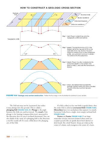
HOW TO CONSTRUCT A GEOLOGIC CROSS SECTION


               Geologic
                 map               45                          45                   D Sh   Devonian shale
                                                                                 S Ss  Silurian sandstone
                      A
                                                                             O      Ordovician limestone
              N                                                               Ls
                                                                         O
                                                                           Ss   Ordovician sandstone


                                                                      Step 1  (red): Project contact lines onto the
                                                                            topographic profile (red dashes).
         Topographic profile


                                                                      Step 2  (green): The sandstone dips 45°E in the
                                                                            eastern half of the map and 45°W on the
                                                                            west side of the map. So from the point
                                                                            where its contacts occur on the topographic
                             45°                            45°             profile, use a protractor and ruler to project
                                                                            the contacts into the subsurface.


                                                                      Step 3  (black): Project the other contacts into the
                                                                            subsurface parallel to the contact lines
                                                                            drawn in step 2, and color the formations if
                                                                            desired.


                                                                      Step 4  (blue): Use dashed lines to project the
                                                                            geologic contacts above the land to visualize
                                                                            the part of the structure that has been
                                                                            eroded.


          FIGURE 10.6    Geologic cross section construction.  Follow the four steps in the illustration to construct a cross section.


              The fold axis may not be horizontal, but rather      If a fold is tilted so that one limb is upside down, then
        it may plunge into the ground. This is called a      the entire fold is called an  overturned fold  (  FIGURE  10.8H   ).

           plunging fold  (  FIGURE  10.8C   ,    D   ).  Plunge  is the angle     Monoclines  have two axial planes that separate two nearly

        between the fold axis and horizontal. The  trend  of the   horizontal limbs from a single, more steeply inclined limb
        plunge is the bearing (compass direction), measured in   (  FIGURE  10.8G   ).

        the direction that the axis is inclined downward. You can      Domes  and  basins  (  FIGURE  10.8E   ,    F   ) are large,

        also think of the trend of a plunging fold as the direction   somewhat circular structures formed when strata are
        a marble would roll if it were rolled down the plunging   warped  upward, like an upside-down bowl (dome) or
        axis of the fold.                                    downward, like a bowl (basin). Strata are oldest at the
                                                             center of a dome, and youngest at the center of a basin.


        268  ■  L ABOR ATORY  10
   293   294   295   296   297   298   299   300   301   302   303