
Page 294 - Laboratory Manual in Physical Geology
P. 294
Attitude—Strike and Dip tilted rock layers or surfaces, so they can visualize how
they have been deformed from their original horizon-
The geologic map and block diagram in FIGURE 10.2 shows tality ( FIGURES 10.3 ). Strike and dip are usually mea-
where each formation occurs but it does not yet include any sured directly from an outcrop using a compass and
information about its three-dimensional orientation. The clinometer (device for measuring the angle of inclined
block diagram in FIGURE 10.2 shows the three- dimensional surfaces). However, they can be measured or estimated
orientation of each formation, but it is an oblique view in by the shapes of landforms observed from a distance or
which angles are distorted. Therefore, geologists must mea- on aerial photographs, orthoimages, and satellite images
sure the orientation of formations, and then record the ori- ( FIGURE 10.4 ).
entation data on maps and block diagrams using symbols.
What Is Strike?
What Is Attitude?
Strike is the compass bearing (line of direction or trend) of a
Attitude is the orientation of a rock unit, surface line formed by the intersection of a horizontal plane, such
(contact), or line relative to horizontal and/or a compass as the surface of a lake, and an inclined surface (contact) or
direction. Geologists have devised a system of strike- rock layer such as a bed, stratum, or formation ( FIGURE 10.3 ).
and-dip for measuring and describing the attitude of
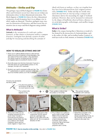
HOW TO VISUALIZE STRIKE AND DIP
1. Strike of an inclined (tilted) surface is a line formed
where the surface intersects a horizontal plane, like
the surface of the water puddle in this illustration.
This strike would be recorded as N 65° E (north Vertical plane
65-degrees east) or an azimuth direction of 65°. Line of strike Dip direction
2. Dip is the angle and direction that water flows (or a
ball rolls) down an inclined (tilted) surface. In this
example, the dip is 30° southeast. Water line
3. Symbols are used to represent strike and dip. The Inclined
“T” symbol below is used to represent strike and surface
dip of an inclined surface, as in this illustration. N 30°
Horizontal plane
Dip angle
30° Line of strike
The long line represents Water
the line of strike. puddle
This short line points in
the direction of dip, like
30° the short hand of a clock.
The number is the or These symbols indicate that This symbol indicates
degrees of dip. the surface is horizontal. that dip is 90° (vertical).
Water
puddle
N
N N
4. This is how strike and dip 5. This is the same porch chair 6. This inclined rock surface is 7. Water flows downhill in the
would be represented on a viewed from directly above; partly under a water puddle. direction of dip. Strike is
porch chair. The seat is same as a geologic map. Strike of the inclined rock always perpendicuar to dip, so
horizontal but the back is Based on the north arrow, the surface is the line formed the strike line can be drawn
steeply inclined. Note that this strike is N 30° W or an azimuth where it intersects the relative to the water line.
is an oblique view like the direction of 330°. horizontal water surface
illustration above and the (shoreline). Dip points down
block diagram in Figure 10.2. towards the water,
perpendicular to strike.
FIGURE 10.3 How to visualize strike and dip. Also refer to FIGURE 10.4 .
264 ■ L ABOR ATORY 10