
Page 292 - Laboratory Manual in Physical Geology
P. 292
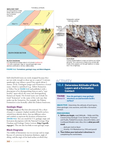
Formation contacts
        GEOLOGIC MAP:
        a 2-dimensional model
        of formations (colors)                       N
        and formation
        contacts.

                                                                        Subparallel vertical
                                                                          fractures (joints)
              Blue Fm     Red Fm      Yellow Fm
                                                             Bedding
                                                               Plane                          Yellow Formation
                                                                                              Y
                                                                                              Yellow Formationellow Formation
                                                              contact
                                                EAST CROSS SECTION  Bedding
                                                             FORMATION
                                                               CONTACT


                                                                Plane
                                                              contacts
                                                                                 Red Formation
          SOUTH CROSS SECTION


                                                                        OUTCROP:
        BLOCK DIAGRAM:                                                  a place where bedrock crops out (sticks out of the
        a 3-dimensional oblique sketch of a block (outlined in          ground). This outcrop is a roadcut (a vertical cliff
        red) with a geologic map on top and geologic cross              made when people cut through bedrock to make
          sections (vertical) on its two visible sides.                 room for a highway).
          FIGURE 10.2    Formations, geologic map, and block diagram.


        Individual beds/strata are rarely mapped because they
                                               1

        are not wide enough to show up on a typical  7    -minute    ACTIVITY

                                               2
        quadrangle map (where a pencil line equals about 6
        meters, 20 ft). Geologists assign each formation a formal   10.4   Determine Attitude of Rock
        name, which is capitalized (e.g., Yellow Formation


        or Yellow Fm in   FIGURE  10.2 ) and published with a         Layers and a Formation

        description of its distinguishing features and a “type        Contact
        locality” upon which the name and distinguishing
                                                                       |
        features are based. The formal name can include the         THINK  How do geologists map geologic
        word “formation” or the name of the rock type that    About It  structures on and beneath Earth’s
        makes up the formation. For example, the Dakota                  surface?
        Formation is also formally called the Dakota Sandstone.
                                                                 OBJECTIVE   Determine the attitude of rock layers,

            Geologic Maps                                     draw geologic cross sections, and infer a formation
           Geologic maps  are flat (two-dimensional, like a sheet   contact.
        of  paper or computer display) models of Earth’s surface,      PROCEDURES
        viewed from directly above, that use different colors        1.     Before you begin , read Attitude—Strike and Dip,
        and symbols to represent the locations of formations      Constructing Geologic Cross Sections, Fractures
         (  FIGURE   10.2 ). You can search for U.S. geologic maps and   and Faults, Folded Structures, Unconformities, and


        formation descriptions with the National Geologic Map
        Database and Geologic Names Lexicon (  http://ngmdb.      Cardboard Models next. Also, this is  what you will
        usgs.gov  ). This site also has links to state geologic maps.     need :
                                                                        ___ dark pen (red or blue)
            Block Diagrams                                          ___ Activity 10.4 Worksheet (p.  276 ) and pencil
          The widths of formations vary in outcrops and on maps       2.     Then follow your instructor’s directions  for
        because of variations in formation thickness, angle of    completing the worksheets.
          tilting, and the angle of the land surface at which they


        262  ■  L ABOR ATORY  10