
Page 287 - Laboratory Manual in Physical Geology
P. 287
A CTIVIT Y 9.5 Relief and Gradient (Slope) Analysis
Name: ___________________________ Course/Section: ____________________________ Date: _____________
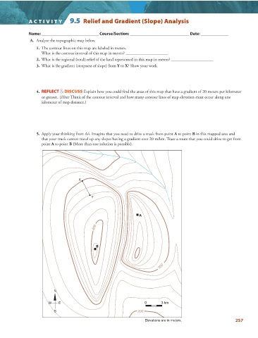
A. Analyze the topographic map below.
1. The contour lines on this map are labeled in meters.
What is the contour interval of this map in meters? ____________________
2. What is the regional (total) relief of the land represented in this map in meters? ____________________
3. What is the gradient (steepness of slope) from Y to X ? Show your work.
4. REFLECT & DISCUSS Explain how you could find the areas of this map that have a gradient of 20 meters per kilometer
or greater. ( Hint: Think of the contour interval and how many contour lines of map elevation must occur along one
kilometer of map distance.)
5. Apply your thinking from A4. Imagine that you need to drive a truck from point A to point B in this mapped area and
that your truck cannot travel up any slopes having a gradient over 20 m/km. Trace a route that you could drive to get from
point A to point B (More than one solution is possible).
X
Y
A
400
B
300
N
W E 0 3 km
S 200
Elevations are in meters. 257