
Page 285 - Laboratory Manual in Physical Geology
P. 285
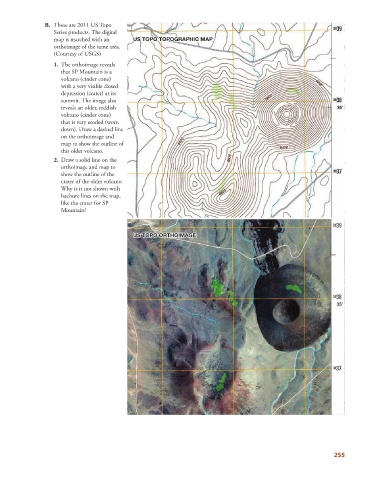
B.     These are 2011 US Topo
                          Series products. The digital
                          map is matched with an     U US TOPO TOPOGRAPHIC MAP
                                                        T

                                                                         C
                                                                         I
                                                         O

                                                                              P
                                                     US TOPO TOPOGRAPHIC MAP
                                                                             A
                                                                           M
                                                      S
                                                          P
                                                                     A
                                                                P
                                                                 O
                                                                    R
                                                                  G
                                                              O
                                                                       H
                                                           O

                                                                      P
                                                             T
                          orthoimage of the same area.
                          (Courtesy of USGS)
                              1.    The orthoimage reveals
                             that SP Mountain is a
                             volcano (cinder cone)
                             with a very visible closed
                             depression (crater) at its
                             summit. The image also
                             reveals an older, reddish
                             volcano (cinder cone)
                             that is very eroded (worn
                             down). Draw a dashed line
                             on the orthoimage and
                             map to show the outline of
                             this older volcano.

                             2.   Draw a solid line on the
                             orthoimage and map to
                             show the outline of the
                             crater of the older volcano.
                             Why is it not shown with
                             hachure lines on the map,
                             like the crater for SP
                             Mountain?
                                                                    I
                                                                    M
                                                                       G
                                                                      A
                                                                         E
                                                        T
                                                         O
                                                          P

                                                     U US TOPO ORTHOIMAGE
                                                     US TOPO ORTHOIMAGE
                                                      S
                                                                T
                                                                 H
                                                                  O
                                                               R
                                                           O

                                                             O


                                                                                                                        255