
Page 284 - Laboratory Manual in Physical Geology
P. 284
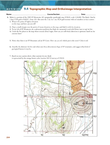
A CTIVIT Y   9.4  Topographic Map and Orthoimage Interpretation


                 Name: ______________________________________   Course/Section: ______________________   Date: ___________


                  A.   Below is a portion of the 1989 SP Mountain, AZ topographic quadrangle map (USGS), scale 1:24,000. The black 1 km by
                   1 km UTM grid is NAD27, Zone 12S. Also note the 1 mi. by 1 mi. PLSS grid sections with red numbers in their centers.

                   1.   What is the point of highest elevation
                     on the map, and how can you tell?

                   2.   Draw a small triangle over the point of lowest elevation on the map, and label it with the elevation.

                   3.   To the left of SP Mountain, do a subtraction problem that finds the mountain’s total relief (from base to top) in feet.
                   4.   Circle the five places in the map where streams (blue) begin. How can you tell which direction is upstream based on the

                     contour lines?


                   5.   Notice that there is an SP Mountain and an SP Crater. How can you tell which part is the crater? Color it red.


                   6.   Describe the diameter (in km and miles) and three-dimensional shape of SP mountain, and suggest what kind of
                     geological feature it may be.


                   7.   Based on your answer above, what material do you think
                     is represented by the orange-brown color (section 34)? (Courtesy of USGS)


               254