
Page 282 - Laboratory Manual in Physical Geology
P. 282
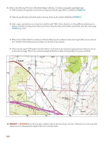
G.   Refer to the following SW corner of the Ritter Ridge, California, 7 1  -minute topographic quadrangle map.
                                                                       2

                       1.   What two kinds of vegetation occur in the area represented by this map? (Refer to symbols in  FIGURE   9.4   )

                      2.   Name the specific kinds of roads located on the map, based on the symbols identified in  FIGURE   9.4   .


                      3.   Gold, copper, and titanium were mined here until the early 1900s. Notice that there are three different symbols used to
                     indicate the kind of mining activity that occurred here. Draw the mine symbols below and identify what they mean using
                     FIGURE 9.4 (p. 234).


                      4.   What are the UTM (NAD27) coordinates of Puritan Mine near the southwest corner of the map? (Hint: Cut out and use

                     the 1:24,000 UTM Grid from Geotools Sheet 4 at the back of the manual.)


                      5.   Notice that the square UTM grids in GeoTools Sheet 4 at the back of the manual are square protractors that you can use
                     to determine bearings. What is the azimuth bearing from Red Rover Mine to Puritan Mine? (Courtesy of USGS)


                     H.       REFLECT & DISCUSS  Below the map above, add bar scales to show how long 1 mile and 1 kilometer are on the map, then
                   explain how you determined the lengths of the bars in your bar scales.


               252