
Page 63 - Laboratory Manual in Physical Geology
P. 63
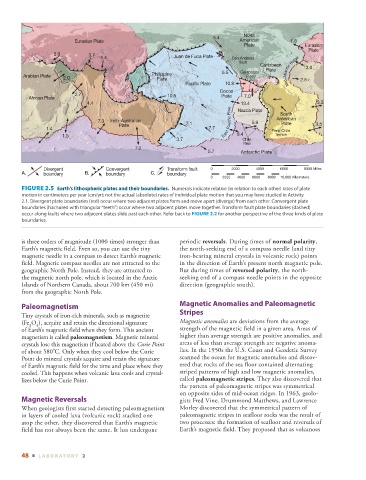
North
                                                                        5.4
                          Eurasian Plate                                         American         1.8
                                                              ▲   ▲   ▲   ▲   ▲   ▲   ▲  Plate         Eurasian
                                                                                                        Plate
                                             ▲    ▲   ▲    ▲   ▲   ▲    ▲   ▲   ▲   ▲   ▲     ▲   ▲   ▲  ▲  fault  Caribbean  3.0
                   3.0         3.7                                          ▲    ▲
                                   5.4                     Juan de Fuca Plate  San Andreas
                ▲    ▲   ▲
                    ▲  ▲     ▲   ▲   ▲   ▲    ▲   ▲   ▲
         Arabian Plate  2.0     ▲   ▲   ▲   ▲   ▲   ▲     ▲     ▲   ▲   ▲   ▲  ▲        ▲   ▲   ▲   ▲   ▲   ▲   ▲   ▲    ▲    ▲      ▲  ▲     ▲    ▲    ▲    ▲    ▲    ▲  ▲  Philippine  5.5  Galapagos  Plate   ▲    ▲   ▲  Mid-Atlantic Ridge  2.5
                                                                                   Rise
                                                     Plate
                                            ▲   ▲
                                                                            10.8
                                              ▲   ▲   ▲        Pacific Plate  Cocos        ▲   ▲
                          2.7                            10.5
           African Plate                               ▲   ▲   ▲   ▲   ▲   Plate   7.0
                                                                                 13.4
                              4.4                       ▲   ▲   ▲    ▲             ▲   ▲   ▲   ▲   ▲   ▲    ▲    ▲    ▲   ▲   ▲   ▲   ▲   ▲   ▲   ▲   ▲   ▲   ▲    ▲  3.5
                                                              ▲   ▲   ▲   ▲      ▲  Nazca Plate  South
                                  7.3  Indo-Australian                       Pacific Rise  5.9  American
                                                                                               Plate
                                             Plate         ▲    ▲  7.1                                    3.5
                1.4                                                    7.7                  Peru-Chile
                      1.5                                                   East  9.4        Trench
                                                            3.7                   Chile
                                                                                  Rise
                                                         ▲   ▲  ▲    ▲
                                              7.2
                                                                      5.7        Antarctic Plate
                Divergent           Convergent           Transform fault  0   2000    4000    6000     8000 Miles
        A.      boundary     B.   ▲   ▲   ▲   ▲  boundary  C.  boundary
                                                                       0   2000  4000  6000  8000  10,000 Kilometers


          FIGURE 2.5    Earth’s lithospheric plates and their boundaries.   Numerals indicate relative (in relation to each other) rates of plate


        motion in centimeters per year (cm/yr); not the actual (absolute) rates of individual plate motion that you may have studied in  Activity

            2.1 . Divergent plate boundaries (red) occur where two adjacent plates form and move apart (diverge) from each other. Convergent plate

        boundaries (hachured with triangular “teeth”) occur where two adjacent plates move together. Transform fault plate boundaries (dashed)


        occur along faults where two adjacent plates slide past each other. Refer back to  FIGURE   2.2  for another perspective of the three kinds of plate
        boundaries.
        is three orders of magnitude (1000 times) stronger than   periodic  reversals . During times of  normal polarity ,
        Earth’s magnetic field. Even so, you can use the tiny   the north-seeking end of a compass needle (and tiny
        magnetic needle in a compass to detect Earth’s magnetic   iron-bearing mineral crystals in volcanic rock) points
        field. Magnetic compass needles are not attracted to the   in the direction of Earth’s present north magnetic pole.
        geographic North Pole. Instead, they are attracted to   But during times of  reversed polarity , the north-
        the magnetic north pole, which is located in the Arctic   seeking end of a compass needle points in the opposite
        Islands of Northern Canada, about 700 km (450 mi)    direction (geographic south).
        from the geographic North Pole.
                                                                 Magnetic Anomalies and Paleomagnetic
            Paleomagnetism
                                                             Stripes
          Tiny crystals of iron-rich minerals, such as magnetite
        (Fe  O  ), acquire and retain the directional signature      Magnetic anomalies  are deviations from the average
           3  4
        of Earth’s  magnetic field when they form. This ancient   strength of the magnetic field in a given area. Areas of
        magnetism is called  paleomagnetism . Magnetic mineral   higher than average strength are positive anomalies, and
        crystals lose this magnetism if heated above the  Curie Point    areas of less than average strength are negative anoma-
        of about 580°C. Only when they cool below the Curie   lies. In the 1950s the U.S. Coast and Geodetic Survey
        Point do mineral crystals acquire and retain the signature   scanned the ocean for magnetic anomalies and discov-
        of Earth’s magnetic field for the time and place where they   ered that rocks of the sea floor contained alternating
        cooled. This happens when volcanic lava cools and crystal-  striped patterns of high and low magnetic anomalies,

        lizes below the Curie Point.                         called  paleomagnetic stripes . They also discovered that
                                                             the pattern of paleomagnetic stripes was symmetrical
                                                             on opposite sides of mid-ocean ridges. In 1963, geolo-
            Magnetic Reversals                               gists Fred Vine, Drummond Matthews, and Lawrence
          When geologists first started detecting paleomagnetism   Morley discovered that the symmetrical pattern of
        in layers of cooled lava (volcanic rock) stacked one     paleomagnetic stripes in seafloor rocks was the result of
        atop the other, they discovered that Earth’s magnetic   two processes: the formation of seafloor and reversals of
        field has not always been the same. It has undergone   Earth’s magnetic field. They proposed that as volcanoes


        48  ■  L ABOR ATORY  2