
Page 240 - Mechatronics for Safety, Security and Dependability in a New Era
P. 240
Ch46-I044963.fm Page 224 Tuesday, August 1, 2006 3:57 PM
Ch46-I044963.fm
224
224 Page 224 Tuesday, August 1, 2006 3:57 PM
We use the SAD (Sum of Absolute Difference) algorithm for the area-based stereo matching in order
to extract disparity image (Moon, et al. 2002). In this study, the walls of buildings are extracted from
the regions with a same value in the disparity image. The Building regions are extracted using the
height information from the disparity information with a priori knowledge of the one-floor height of
building.
Vanishing Points
A non-vertical skyline caused by the roof of a building can provide information on the relative
orientation between the robot and the building. What is necessary for estimating the relative
orientation is the vanishing point. We first calculate the vanishing points of the non-vertical skylines
with the horizontal scene axis. And we estimate an angle between the image plane and the line from
the camera center to a vanishing point which is parallel to the direction of a visible wall in the building.
Corners of Buildings
The boundaiy lines are the vertical skylines of buildings adjoining to the sky regions (Katsura, et al.
2003). The boundary lines correspond to the corners of buildings on the given map.
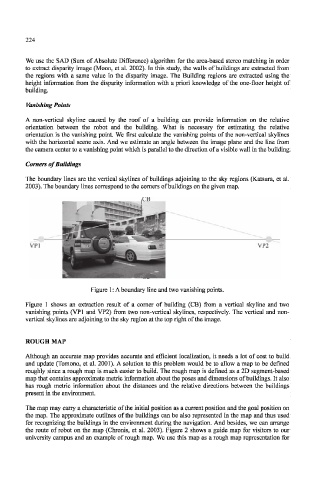
Figure 1: A boundary line and two vanishing points.
Figure 1 shows an extraction result of a corner of building (CB) from a vertical skyline and two
vanishing points (VP1 and VP2) from two non-vertical skylines, respectively. The vertical and non-
vertical skylines are adjoining to the sky region at the top right of the image.
ROUGH MAP
Although an accurate map provides accurate and efficient localization, it needs a lot of cost to build
and update (Tomono, et al. 2001). A solution to this problem would be to allow a map to be defined
roughly since a rough map is much easier to build. The rough map is defined as a 2D segment-based
map that contains approximate metric information about the poses and dimensions of buildings. It also
has rough metric information about the distances and the relative directions between the buildings
present in the environment.
The map may carry a characteristic of the initial position as a current position and the goal position on
the map. The approximate outlines of the buildings can be also represented in the map and thus used
for recognizing the buildings in the environment during the navigation. And besides, we can arrange
the route of robot on the map (Chronis, et al. 2003). Figure 2 shows a guide map for visitors to our
university campus and an example of rough map. We use this map as a rough map representation for