
Page 170 - Modern Spatiotemporal Geostatistics
P. 170
Uncertainty Assessment 151
Minimum mean squared error (MMSE) techniques (see, e.g., Davis,
1986) offer a measure of mapping accuracy in terms of the estimation root-
squared-error average. In theory, a large number of realizations is assumed and
the right-hand side of Equation 8.2 is determined as the average
over all realizations N r. In practice, however, Equation 8.5 is usually calculated
in terms of the means and correlation functions (covariances, variograms, etc.),
which have been approximated on the basis of the single realization (measured
values) available, using some ergodicity assumption. In many cases, this ap-
proach can lead to questionable approximations (e.g., Stein, 1999). Also, while
most traditional MMSE techniques do not have the mechanism that would al-
low them to incorporate most forms of physical knowledge, the BME method
accounts for both general and specificatory knowledge bases.
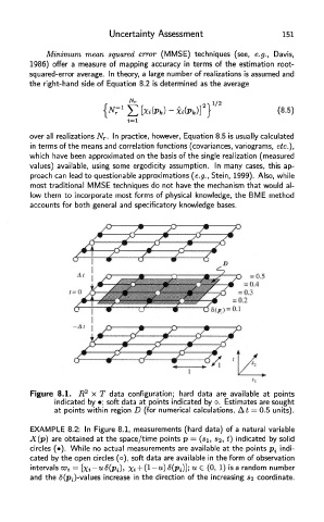
Figure 8.1. R 2 x T data configuration; hard data are available at points
indicated by •; soft data at points indicated by o. Estimates are sought
at points within region D (for numerical calculations, At = 0.5 units).
EXAMPLE 8.2: In Figure 8.1, measurements (hard data) of a natural variable
X(p) are obtained at the space/time points p = (si, $2, *) indicated by solid
circles (•). While no actual measurements are available at the points p, indi-
cated by the open circles (o), soft data are available in the form of observation
intervals 's a random number
and the S(p i)-va\ues increase in the direction of the increasing s 2 coordinate.