
Page 226 - Modern Spatiotemporal Geostatistics
P. 226
Single-Point Analytical Formulations 207
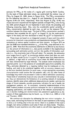
estimate for PMi 0 at the nodes of a regular grid covering North Carolina.
On the basis of these estimated values, we constructed the contour map of
PMio for August 25, 1995, shown in Figure 10.4a. The PM 10 concentration
for the following two days (i.e., August 31 and September 6) are shown in
Figures 10.4b and 10.4c, respectively. Note that August 31 (Fig. 10.4b) was
chosen because it experienced the highest spatially averaged PMio value during
the 1995 period (August 25 and September 6 were simply the preceding and
following measuring days). Also, note the considerable spatial variability of
PMio concentration depicted by each map, as well as the temporal PMio
variation between the three maps. The level of PMio concentration reached a
maximum that exceeded the 60 /ug/m 3 on August 31 (at the north-central
region of the state) and then decreased to below 40 jug/m 3 on September 6.
These maps are based on an integrated analysis of space and time which
accounts for important cross-correlations and dependencies between PMio con
centrations at various spatial locations and time instants. In Figure 10.5 we
plot the BME error standard deviation cr^of the PMio map obtained on Au-
gust 31, 1995. Note that the uncertainty distribution is affected by two factors:
(i.) the amount of information (i.e., data points available in the neighborhood
surrounding each estimation point), and (ii.) the quality of information avail-
able (i.e., the uncertainty level of the soft data). For example, the estimation
error ranges from 0 /xg/m 3 at monitoring stations where hard data are avail-
3
able, to higher values (up to 7.5 /ig/m ) at regions away from these stations.
In addition, a high level of uncertainty occurs when the BME estimates use
soft data characterized by large intervals. The analysis above emphasizes two
essential points: (a) in the presence of considerable space/time variability, the
PMio estimates obtained by a mapping method may be inadequate or mis-
leading, and need to be considered together with an accuracy measure such
as the error standard deviation (in some cases, a more appropriate uncertainty
characterization could involve the full posterior pdf); and (6) other forms of
knowledge may need to be processed in order to reduce estimation uncertainty.
These kinds of uncertainty maps are very valuable in environmental risk analy-
sis: they can demonstrate the limitations of an existing network of monitoring
stations, identify areas where additional observations are needed, optimize the
design of future networks, provide uncertainty indicators for use in health risk
management systems, etc. In conclusion, numerical implementations of the
BME method produce accurate pollutant estimates for use in spatiotemporal
mapping applications, and realistic measures of the relevant uncertainties for
use in decision making and environmental risk assessment applications (a dis-
cussion of these applications may be found, e.g., in Dab et al., 1996 or in Ito
and Thurston, 1996).
We continue our discussion by addressing the rear mirror metaphor. In
many cases, estimating the future on the basis of past experience is like trying
to drive a car looking only in the rear mirror: there is no problem if the road is
straight, but serious problems could arise if there are sharp bends. Therefore,
in addition to past experience one often needs to use soft data regarding future