
Page 217 - Petroleum Geology
P. 217
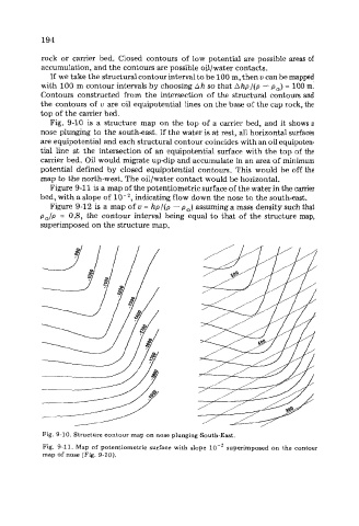
194

            rock  or  carrier  bed.  Closed  contours of  low potential  are possible areas of
            accumulation, and the contours are possible oil/water contacts.
              If  we take the structural contour interval to be 100 m, then u can be mapped
            with 100 m contour intervals by choosing Ah so that Ahp/(p - p,)  = 100 m.
            Contours  constructed  from the  intersection  of  the structural contours and
            the contours of  u  are oil equipotential lines on the base of the cap rock, the
            top of the carrier bed.
              Fig.  9-10 is  a  structure  map  on the top of  a carrier bed, and it shows a
            nose plunging to the southeast. If  the water is at rest, all horizontal surfaces
            are equipotential and each structural contour coincides with an oil equipoten-
            tial  line  at  the  intersection of  an equipotential surface with the top of  the
            carrier bed. Oil would migrate updip and accumulate in an area of minimum
            potential  defined  by  closed  equipotential contours.  This would be off  the
            map to the north-west. The oil/water contact would be horizontal.
              Figure 9-11 is a map of the potentiometric surface of the water in the carrier
           bed, with a slope of     indicating flow down the nose to the south-east.
              Figure 9-12 is a map of  u = hp /(p - p,)  assuming a mass density such that
           po/p  =  0.8,  the  contour  interval being  equal to that of  the structure map,
            superimposed on the structure map.


            Fig. 9-10. Structure contour map on nose plunging South-East.
            Fig.  9-11. Map  of potentiometric  surface with  slope  lo-’  superimposed  on the contour
            map of nose (Fig. 9-10).