
Page 257 - Planning and Design of Airports
P. 257
220 Airp o r t D e sign
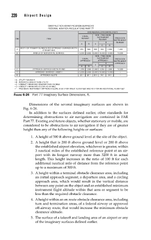
OBSTRUCTION IDENTIFICATION SURFACES
FEDERAL AVIATION REGULATIONS PART 77
DIMENSIONAL STANDARDS (FEET)
NON - PRECISION
VISUAL INSTRUMENT
PRECISION
DIM ITEM RUNWAY RUNWAY INSTRUMENT
B RUNWAY
A B A
C D
WIDTH OF PRIMARY SURFACE AND APPROACH SURFACE WIDTH
A 250 500 500 500 1,000 1,000
AT INNER END
B RADIUS OF HORIZONTAL SURFACE 5,000 5,000 5,000 10,000 10,000 10,000
NON - PRECISION
VISUAL INSTRUMENT PRECISION
APPROACH APPROACH INSTRUMENT
B APPROACH
A
A B C D
C APPROACH SURFACE WIDTH AT END 1,250 1,500 2,000 3,500 4,000 16,000
D APPROACH SURFACE LENGTH 5,000 5,000 5,000 10,000 10,000 *
E APPROACH SLOPE 20:1 20:1 20:1 34:1 34:1 *
• A - UTILITY RUNWAYS
• B - RUNWAYS LARGER THAN UTILITY
• C - VISIBILITY MINIMUMS GREATER THAN 3/4 MILE
• D - VISIBILITY MINIMUMS AS LOW AS 3/4 MILE
• * - PRECISION INSTRUMENT APPROACH SLOPE IS 50:1 FOR INNER 10,000 FEET AND 40:1 FOR AN ADDITIONAL 40,000 FEET
FIGURE 6-26 Part 77 Imaginary Surface Dimensions, ft.
Dimensions of the several imaginary surfaces are shown in
Fig. 6-26.
In addition to the surfaces defined earlier, other standards for
determining obstructions to air navigation are contained in FAR
Part 77. Existing and future objects, whether stationary or mobile, are
considered to be obstructions to air navigation if they are of greater
height than any of the following heights or surfaces:
1. A height of 500 ft above ground level at the site of the object.
2. A height that is 200 ft above ground level or 200 ft above
the established airport elevation, whichever is greater, within
3 nautical miles of the established reference point at an air-
port with its longest runway more than 3200 ft in actual
length. This height increases in the ratio of 100 ft for each
additional nautical mile of distance from the reference point
up to a maximum of 500 ft.
3. A height within a terminal obstacle clearance area, including
an initial approach segment, a departure area, and a circling
approach area, which would result in the vertical distance
between any point on the object and an established minimum
instrument flight altitude within that area or segment to be
less than the required obstacle clearance.
4. A height within an en route obstacle clearance area, including
turn and termination areas, of a federal airway or approved
off-airway route, that would increase the minimum obstacle
clearance altitude.
5. The surface of a takeoff and landing area of an airport or any
of the imaginary surfaces defined earlier.