
Page 323 - Soil and water contamination, 2nd edition
P. 323
310 Soil and Water Contamination
Region type of system
of ground-water flow
Topographic elevation and head of water above standard datum Regional
Local
Intermediate
Line of force
Boundary between flow
system of similar order
Potential distribution
on the surface of the
theoretical flow region
Stagnation point
6642 6642 6642
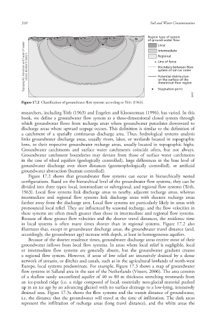
Figure 17.2 Classification of groundwater flow systems according to Tóth (1963).
researchers, including Tóth (1963) and Engelen and Kloosterman (1996), has varied. In this
book, we define a groundwater flow system as a three-dimensional closed system through
which groundwater flows from recharge areas where groundwater percolates downward to
discharge areas where upward seepage occurs. This definition is similar to the definition of
a catchment of a spatially continuous discharge area. Thus, hydrological systems analysis
links groundwater discharge areas, usually rivers, lakes, or wetlands located in topographic
lows, to their respective groundwater recharge areas, usually located in topographic highs.
Groundwater catchments and surface water catchments coincide often, but not always.
Groundwater catchment boundaries may deviate from those of surface water catchments
in the case of tilted aquifers (geologically controlled), large differences in the base level of
groundwater discharge over short distances (geomorphologically controlled), or artificial
groundwater abstraction (human controlled).
Figure 17.2 shows that groundwater flow systems can occur in hierarchically nested
configurations. Based on the hierarchical level of the groundwater flow systems, they can be
divided into three types: local, intermediate or subregional, and regional flow systems (Tóth,
1963). Local flow systems link discharge areas to nearby, adjacent recharge areas, whereas
intermediate and regional flow systems link discharge areas with discrete recharge areas
farther away from the discharge area. Local flow systems are particularly likely in areas with
pronounced local relief. They are influenced by seasonal recharge, and the flow velocities in
these systems are often much greater than those in intermediate and regional flow systems.
Because of these greater flow velocities and the shorter travel distances, the residence time
in local systems is often many times shorter than in regional systems. Figure 17.2 also
illustrates that, except in groundwater discharge areas, the groundwater travel distance (and,
accordingly, the groundwater age) increase with depth, at least in homogeneous aquifers.
Because of the shorter residence time s, groundwater discharge areas receive most of their
groundwater inflows from local flow systems . In areas where local relief is negligible, local
or intermediate flow systems are generally absent, but the groundwater gradient creates
a regional flow system. However, if areas of low relief are intensively drained by a dense
network of streams, or ditches and canals, such as in the agricultural lowlands of north-west
Europe, local systems predominate. For example, Figure 17.3 shows a map of groundwater
flow systems in Salland area in the east of the Netherlands (Vissers, 2006). The area consists
of a shallow sandy unconfined aquifer of 40 to 80 m thickness stretching westwards from
an ice-pushed ridge (i.e. a ridge composed of local, essentially non-glacial material pushed
up in an ice age by an advancing glacier) with no surface drainage to a low-lying, intensively
drained area. Figure 17.3a shows the flow systems and the transit distance of groundwater,
i.e. the distance that the groundwater will travel at the time of infiltration . The dark areas
represent the infiltration of recharge areas (long travel distance), and the white areas the
10/1/2013 6:45:35 PM
Soil and Water.indd 322 10/1/2013 6:45:35 PM
Soil and Water.indd 322