
Page 351 - Soil and water contamination, 2nd edition
P. 351
338 Soil and Water Contamination
6642 100 km
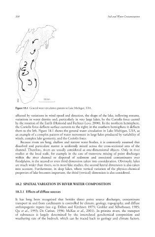
Figure 18.1 General water circulation pattern in Lake Michigan, USA.
affected by variations in wind speed and direction, the shape of the lake, inflowing streams,
variations in water density and, particularly in very large lakes, by the Coriolis force caused
by the rotation of the Earth (Hemond and Fechner-Levy, 2000). In the northern hemisphere,
the Coriolis force deflects surface currents to the right; in the southern hemisphere it deflects
them to the left. Figure 18.1 shows the general water circulation in Lake Michigan , USA, as
an example of a complex pattern of water movement in large lakes produced by variability of
winds, complex lake geometry, and the Coriolis force.
Because rivers are long, shallow and narrow water bodies, it is commonly assumed that
dissolved and particulate matter is uniformly mixed across the cross-sectional area of the
channel. Therefore, rivers are usually considered as one-dimensional objects. Only in river
studies at the local scale , for example in the case of transverse mixing of point discharges
within the river channel or dispersal of sediment and associated contaminants over
floodplains , is the second or even third dimension taken into consideration. Obviously, lakes
are much wider than rivers, so in most lake studies, the second lateral dimension is also taken
into account. Furthermore, in deep lakes, where vertical variation of the physico-chemical
properties of lake becomes important, the third (vertical) dimension is also considered.
18.2 SPATIAL VARIATION IN RIVER WATER COMPOSITION
18.2.1 Effects of diffuse source s
It has long been recognised that besides direct point source discharges, contaminant
transport in and from catchments is controlled by climate, geology, topography, and diffuse
anthropogenic inputs (see e.g. Dillon and Kirchner, 1975; Grobler and Silberbauer, 1985;
Qu et al., 1993; De Caritat, 1996; McKee et al., 2001). In pristine rivers , the transport
of substances is largely determined by the interrelated geochemical composition and
weathering rate of the bedrock, which can be traced back to geology and climate factors,
10/1/2013 6:47:10 PM
Soil and Water.indd 350 10/1/2013 6:47:10 PM
Soil and Water.indd 350