
Page 16 - Sumatra Geology, Resources and Tectonic Evolution
P. 16
INTRODUCTION 3
i I
90 ~ l'-, ' O0 ~ 110 ~
b, CHINA
BANGLA-
INDIA DESH
. \'\ .\.\ ,,," 20 ~
,\.\\ ,,.'
MYANMAR
[ "~ SOUTH
::::BENGAL:::::: 7 ! t CHINA
9 """ FAN[" i" [ 9 i--?/ ! l ..... -i 4 SEA
"
i I
\i 1
: : : : 2~?:: : : "Nl
-.'1.0ON::': ". :. :-:. :. :. ] , ,
9 : :::::: : ;::iiil
,\ 2r
,~. S
Z
:
:
:
:
: .......::::::: :::~i 0'
9 : : : : : : :':::~:
.....................
.J . . . . . . . . . . . . . BORNEO
...........................
/:'.'.'.'.'.'.'.'.'.'.
.
9 ........
::::::: ~:-:-:.:::.:-:-:.:-:.:.:-:.:.:.:..
:::::: ~i!i!iii!iii! FANiiii!iiii!i!iii:....~.~
. . . . . . .:.............%....%-.. . . . . . . . . . . . . . . .
:.:.:.:.:.:.:.:.:.:.:.:.:.:.:.:.:.:.:.:.:.:.:.
.
.
.
.
.
.
.
.
9 .'.'. ".'. ". _ . . . . . . . . . . . .
================================================
::::: :: ........................ ....... ,....-~,-"
. .....-.........-........-...l
. . . . . .
: : : : : : ::::::::::::::::::::::::: . ,
............................,~.
. . . . . . . . . .
. . . . . . . . . . . . . . . .
t __ ::::::::::::::::::: )
. . . . . . ".,
-10os
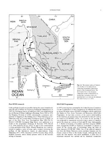
Fig. 1.2. The tectonic setting of Sumatra
Christmas o
Is with the floor of the Indian Ocean
subducting beneath the southwestern
INDIAN Keeling Is~176 i margin of the Sundaland Craton. The
deformation front of the Sumatran
OCEAN 0 500 1000km subduction system is indicated by the
toothed line; spreading centres and
I I I
90 ~ 100 ~ transform faults are shown in the Andaman
I I I Sea (after Curray et al. 1979).
Post-WWII research SEATAR Programme
Little geological work was possible during the years immediately In 1973 a meeting was convened by the United Nations Committee
after the end of WWII, but following Indonesian Independence in for the Coordination of Joint Prospecting for Mineral Resources
1947 the Geological Survey of Indonesia (GSI) was established in in Asian Off-shore waters (CCOP) in Bangkok which established
the old Bureau of Mines building in Bandung. From 1969 to 1974 the Studies in East Asian Tectonics and Resources (SEATAR)
the Mapping Division of (GSI) commenced a systematic pro- Programme. At that time a review of the current understanding
gramme of mapping in the Padang area of West Sumatra, in col- of the tectonics of eastern Asia was prepared by Deryck Laming
laboration with the United States Geological Survey (USGS), as on behalf of CCOP-IOC (1974). As a result of the meeting it
part of the First Five Year Development Plan (PELITA I). was proposed to concentrate research along a series of transects
Several 1:250 000 Geological Map Sheets were published as a across the island arc systems of East and SE Asia. Subsequently
result of this programme (Silitonga & Kastowo 1975; Rosidi A. J. Barber (University of London) and Derk Jongsma (BMR)
et al. 1976; Kastowo & Leo 1973). As part of this collaboration were engaged by CCOP as Technical Consultants to prepare a
a senior geologist of the USGS, Warren Hamilton, was commis- report on the current state of knowledge along the lines of
sioned to prepare a series of maps and a memoir reviewing the these transects (CCOP-IOC 1980). One of the selected transects
geology of the Indonesian region in plate-tectonic terms ran from the Malay Peninsula across northern Sumatra and the
(Hamilton 1977, 1979). Hamilton's (1979)Tectonic Map, which forearc island of Nias to the Sunda Trench. Although the final
includes Sumatra, shows clearly present views of the tectonic report for this transect was never published, a great deal of
setting of Sumatra. important research was carried out by American researchers