
Page 21 - Sumatra Geology, Resources and Tectonic Evolution
P. 21
8 CHAPTER 2
Central Domain
Southern Domain
Northern Domain
1000 ~ LINE --~l
42-43 Batu
pora N.
Elbow'
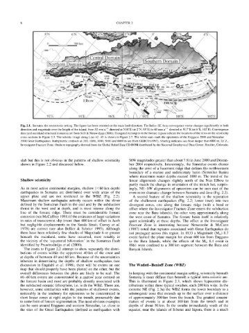
Fig. 2.1. Sumatra: the neotectonic setting. The figure has been oriented on the main fault direction. The India-SE Asia convergence vector changes significantly in both
direction and magnitude over the length of the island, from 52 mm a-1 directed at N10~ (at 2~ 95~ to 60 mm a-l directed at N 17~ (at 6~ 102~ Convergence
data (and mainland structural domains) are from Sieh & Natawidjaja (2000). Elongated rectangles in the forearc region indicate the locations of the zeros on the seismicity
cross-sections in Figure 2.3. The seismic image along Line 42-43 is shown in Figure 2.7. The white stars mark the epicentres of the Enggano 2000 and Simeulue
2004 Great Earthquakes. Bathymetric contours at 200, 1000, 3000, 5000 and 6000 m are from GEBCO (1997). Shading indicates sea floor deeper than 6000 m. I.F.Z.,
Investigator Fracture Zone. Onshore topography derived from the Global Relief Data CD-ROM distributed by the National Geophysical Data Center, Boulder, Colorado.
slab but this is not obvious in the patterns of shallow seismicity MW magnitudes greater than about 7.8) in June 2000 and Decem-
shown in Figure 2.2 and discussed below. ber 2004 respectively. Interestingly, the Simeulue events cluster
along the crest of a basement ridge that defines the northwestern
boundary of a marine and sedimentary basin (Simeulue Basin)
where maximum water depths exceed 1000 m. The trend of the
Shallow seismicity linear alignments changes slightly north of the Nias Elbow to
partly match the change in orientation of the trench but, surpris-
As in most active continental margins, shallow (<60 km depth) ingly, NE-SW alignments of epicentres can be seen east of the
earthquakes in Sumatra are distributed over wide areas of the even more dramatic change between Sumatra and Java (Fig. 2.2).
upper plate and are not restricted to the WBZ (Fig. 2.2). A second feature of the shallow seismicity is the separation
Maximum shallow earthquake activity occurs within the sliver of the shallowest earthquakes (Fig. 2.2; lower inset) into two
defined by the Sumatran Fault in the east and by the subduction divergent zones, one along the forearc ridge (with a bend or
thrust in the west and at depth, and is most intense along the offset where the Investigator Fracture Zone enters the subduction
line of the forearc ridge. There must be considerable forearc zone near the Batu islands), the other very approximately along
extension (see McCaffrey 1991 ) if the estimates of large variations the west coast of Sumatra. The forearc basin itself is relatively
in rates of transcurrent slip (more than 400 km of offset in Aceh quiet seismically at these depths. The offset at the Investigator
but negligible displacements in the Sunda Strait; Curray et al. Fracture Zone is interesting because Newcombe & McCann
1978) are correct (see also Bellier & Sebrier 1995). Although (1987) noted that ruptures associated with Great Earthquakes do
there have been relatively few shocks of Magnitude 6 or greater not propagate across this region. In 1833 a Magnitude (Mw) 8.7
beneath the mainland, some have occurred, most notably in event faulted the plate margin for about 600 km from Enggano
the vicinity of the 'equatorial bifurcation' in the Sumatran Fault to the Batu Islands, while the effects of the Mw 8.4 event in
identified by Prawirodirdjo et al. (2000). 1861 were confined to a 300 km segment between the Batu and
The insets to Figure 2.2 attempt to show separately the distri- Banyak Islands.
butions of events within the uppermost 40 km of the crust and
at depths of between 40 and 60 km. Because of the uncertainties
inherent in determining the depths of shallow earthquakes (see
discussion in Engdahl et al. 1998), there will be events on one The Wadati-Benioff Zone (WBZ)
map that should properly have been plotted on the other, but the
overall differences between the plots are likely to be real. The In keeping with the continental margin setting, seismicity beneath
40-60 km events are concentrated in a narrow zone centred on Sumatra is more diffuse than beneath a typical intra-oceanic arc.
the forearc basin and most are probably directly associated with This is illustrated in Figure 2.3, which shows hypocentre dis-
the subducted oceanic lithosphere, i.e. with the WBZ. There are, tributions within three typical swathes, each 200 km wide. In the
however, some similarities with the patterns of shallower events, extreme NE (Fig. 2.3a) the WBZ forms the lower boundary to a
noticeably in the tendency for epicentres to be concentrated in seismogenic zone that extends up to the surface over a distance
short linear zones at right angles to the trench, presumably due of approximately 300 km from the trench. The greatest concen-
to some form of forearc segmentation. The most obvious examples tration of events is at about I00 km from the trench and at
can be seen around Enggano and western Simeulue, i.e. close to depths of about 50 km. In the swathe immediately south of the
the sites of the Great Earthquakes (defined as earthquakes with equator, near the islands of Siberut and Sipora, there is a much