
Page 25 - Sumatra Geology, Resources and Tectonic Evolution
P. 25
12 CHAPTER 2
dated by slip on the Mentawai Fault. Their proposed defor- Seismic reflection sections from many parts of the basin
mation history (which they emphasized was only one of a mul- favour localized faulting in the forearc basin, since deformation
titude of possibilities) involved arc-parallel stretching during the of Late Neogene sediments is generally confined to the narrow
Pleistocene but provided no role for the segment of the Menta- zone close to the eastern coasts of the forearc islands which was
wai Fault north of the Nias Elbow. named the Mentawai Fault by Diament et al. (1992). However,
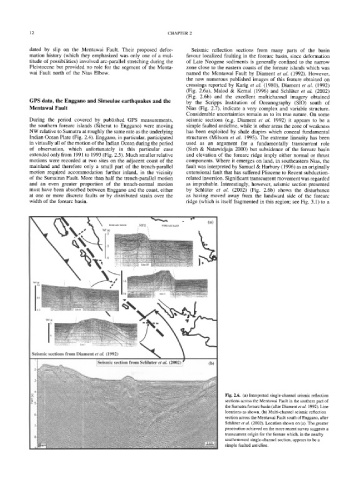
the now numerous published images of this feature obtained on
crossings reported by Karig et al. (1980), Diament et al. (1992)
(Fig. 2.6a), Malod & Kemal (1996) and Schlfiter et al. (2002)
(Fig. 2.6b) and the excellent multichannel imagery obtained
GPS data, the Enggano and Simeulue earthquakes and the by the Scripps Institution of Oceanography (SIO) south of
Mentawai Fault Nias (Fig. 2.7), indicate a very complex and variable structure.
Considerable uncertainties remain as to its true nature. On some
During the period covered by published GPS measurements, seismic sections (e.g. Diament et al. 1992) it appears to be a
the southern forearc islands (Siberut to Enggano) were moving simple faulted anticline, while in other areas the zone of weakness
NW relative to Sumatra at roughly the same rate as the underlying has been exploited by shale diapirs which conceal fundamental
Indian Ocean Plate (Fig. 2.4). Enggano, in particular, participated structures (Milsom et al. 1995). The extreme linearity has been
in virtually all of the motion of the Indian Ocean during the period used as an argument for a fundamentally transcurrent role
of observation, which unfortunately in this particular case (Sieh & Natawidjaja 2000) but subsidence of the forearc basin
extended only from 1991 to 1993 (Fig. 2.5). Much smaller relative and elevation of the forearc ridge imply either normal or thrust
motions were recorded at two sites on the adjacent coast of the components. Where it emerges on land, in southeastern Nias, the
mainland and therefore only a small part of the trench-parallel fault was interpreted by Samuel & Harbury (1996) as an originally
motion required accommodation further inland, in the vicinity extensional fault that has suffered Pliocene to Recent subduction-
of the Sumatran Fault. More than half the trench-parallel motion related inversion. Significant transcurrent movement was regarded
and an even greater proportion of the trench-normal motion as improbable. Interestingly, however, seismic section presented
must have been absorbed between Enggano and the coast, either by Schltiter et al. (2002) (Fig. 2.6b) shows the disturbance
at one or more discrete faults or by distributed strain over the as having moved away from the landward side of the forearc
width of the forearc basin. ridge (which is itself fragmented in this region; see Fig. 3.1) to a
/'~ ~ ~ ~ " r (a)
l" i
. . . . . . . . 9 2.5
!
Seismic sections from Diament et al. (1992) "~
Fig. 2.6. (a) Interpreted single-channel seismic reflection
sections across the Mentawai Fault in the southern part of
the Sumatra forearc basin (after Diament et al. 1992). Line
locations as shown. (b) Multi-channel seismic reflection
section across the Mentawai Fault south of Enggano, after
Schltiter et al. (2002). Location shown on (a). The greater
penetration achieved on the more recent survey suggests a
transcurrent origin for the feature which, in the nearby
southernmost single-channel section, appears to be a
simple faulted anticline.