
Page 24 - Sumatra Geology, Resources and Tectonic Evolution
P. 24
SEISMOLOGY & NEOTECTONICS 11
on this portion of the Sumatran Fault, but revealed very consider- an asperity on the lower plate. However, the magnitude of the
able differences in detail in both movement magnitudes and December 2004 Simeulue earthquake suggests a 'sticky', rather
directions. than well-lubricated, fault zone.
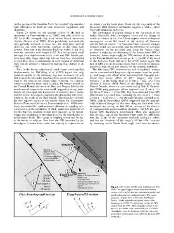
Figure 2.4 shows the site motions relative to SE Asia as The combination of gradual change in the orientation of the
interpreted by Prawirodirdjo et al. (1997) and (also relative to Indian Ocean/SE Asia convergence vector and the change in
SE Asia) the averaged long term Indian Ocean movement trench orientation at the Nias Elbow implies almost orthogonal
vectors (Demets et al. 1990). Strain partitioning was evidently convergence across the trench in the vicinity of Simeulue
only partially achieved, at least over the short time interval and the Banyak Islands. The Sumatran Fault, however, changes
involved, nor were movements confined to the main fault direction much less noticeably, and the differences in curvature
systems. Sites east of the Sumatran Fault but within 50 km of it of structures on the mainland and along the forearc ridge
were not stationary with respect to SE Asia but recorded small produce a widening and deepening of the forearc basin NW of
but significant displacements to the north and NW. Similar pat- Simeulue. Rather surprisingly, the GPS motions of the two sites
terns near other major strike-slip features have been interpreted in the Banyak Islands were almost perfectly parallel to the trend
as recording stress accumulations in wide regions of deformed of the Sumatran Fault, and so to the trench further south. The
rock that are ultimately released by faulting (e.g. Armijo et al. lack of GPS sites on Simeulue means that short-term neotectonic
1999). patterns in this critical area remain, for the moment, undefined.
Sites in the forearc experienced much larger trench-parallel The data from GPS measurements and triangulation surveys
displacements, but McCaffrey et al. (2000) argued that only can be compared with long-term slip estimates based on geolo-
about two-thirds of the necessary slip was accounted for and gic and topographic offsets at the Sumatran Fault. Slip rates esti-
that most of the remainder must have been accommodated ocean- mated from stream offsets on SPOT imagery vary from
ward of the crest of the forearc ridge. However, the situation 10 mm a -1 at the Sunda Strait to 23 mm a -1 near Lake Toba
varied considerably from place to place. On forearc islands in (Bellier & Sebrier 1995). Much of this change occurs in the
the Central Domain (between the Batu and Banyak Islands) the Central Domain, where the rates estimated by Sieh & Natawid-
trench-normal components were small, suggesting strong parti- jaja (2000) using geological offsets increase from 11 mm a i in
tioning of convergent and transcurrent movements, but it seems the SE to 27 mm a-1 in the NW. Slip rates estimated from GPS
that the forearc was largely coupled to the downgoing slab every- observations vary much less, increasing by only 4 mm a -1, from
where to the south of the Batu Islands. The boundary between 23 mm a-1 to 27 mm a-1, over the same distance (Genrich et al.
the two regimes occurs in the region where the Investigator 2000). Sieh & Natawidjaja (2000) suggested that the geologi-
Fracture Zone enters the trench. Prawirodirdjo et al. (1997) tenta- cally indicated changes in slip rates along the fault must have
tively interpreted the northwestwards decrease in coupling as a developed only during the last 100 ka, because of the absence
consequence of the subduction of thick, water-rich sediments of of compressional accommodation structures, but left the geo-
the Nicobar Fan, resulting in high pore pressures in the forearc logical-GPS discrepancy unexplained. They also suggested
wedge and weakening of the upper plate by the introduction of that the total slip on the Sumatran Fault might be little more
hydrothermal fluids. The change in coupling would thus be due than the 20 km of the maximum verifiable geological offset,
to the barrier to sediment flow from the NW presented by the and that the remainder of the roughly 100 km offset required
Investigator Fracture Zone, rather than directly to its presence as by stretching in the Sunda Strait might have been accommo-
Fig. 2.5. GPS vectors and the Great Earthquake of June
2000. The upper diagram shows overall movement
vectors relative to SE Asia and their trench-parallel and
Trench-orthogonal motion Trench-parallel motion trench-orthogonal resolved components. The lower
diagrams compare these components individually.
1 2 Vector 1 is the regional convergence vector, after
Demets et al. (1990). The remaining vectors are GPS
vectors from the 1991-1993 campaign at sites at the
bases of the arrows, after Prawirodirdjo et al. (1997).
'Beachballs' show the locations of the two subevents
proposed by Abercrombie et al. (2002) for the June 2000
earthquake.