
Page 23 - Sumatra Geology, Resources and Tectonic Evolution
P. 23
10 CHAPTER 2
~.Lake
%
Equator
Batu
IS.
I Indian ~
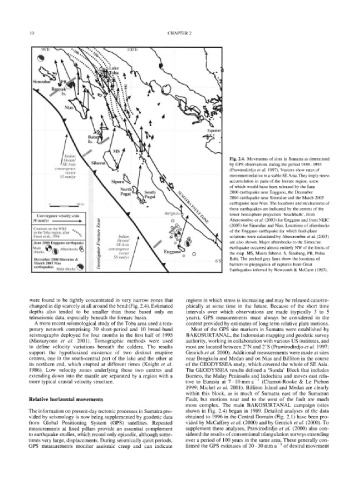
: [Ocean/ Fig. 2.4. Movements of sites in Sumatra as determined
SE Asia by GPS observations during the period 1989-1993
convergence
(Prawirodirdjo et al. 1997). Vectors show rates of
...................... vector;
52 mm/yr Sipor movement relative to a stable SE Asia. They imply stress
accumulation in parts of the forearc region, some
of which would have been released by the June
k, pNgr taih ~'~f~ S~ 2000 earthquake near Enggano, the December
N ~l'~gal 2004 earthquake near Simeulue and the March 2005
earthquake near Nias. The locations and mechanisms of
0 300 km
these earthquakes are indicated by the centres of the
i 9
BengkulL
Convergence velocity scale .... X lower hemisphere projection 'beachballs', from
50mm/yr % ~ [! ~ o Abercrombie et al. (2003) for Enggano and from NEIC
. . . . .
Contours on the WBZ (2005) for Simeulue and Nias. Locations of aftershocks
in the Toba region, after %. of the Enggano earthquake for which fault-plane
.
.
.
Fauzi et al., 1996 . * !~ Indian. solutions were calculated by Abercrombie et al. (2003)
.
June 2000 Enggano earthquake ~ Ocean/ I f are also shown. Major aftershocks to the Simeulue
~
Main ~ Aftershocks~ ~ " convergence / earthquake occurred almost entirely NW of the limits of
SEAsia [
shocks ~ k.' ~ vector I Engganc o 0 the map. MS, Muara Siberut. S, Sinabang, PB, Pulau
December 2004 Simeulue & "~ 58 mm/vr/7 .... Babi. The pecked grey lines show the locations of
March 2005 Nias ,IL / ........ ............................. 6"S
earthquakes Main shocks ~ ~ barriers to propagation of ruptures from Great
Earthquakes inferred by Newcomb & McCann (1987).
were found to be tightly concentrated in very narrow zones that regions in which stress is increasing and may be released catastro-
changed in dip scarcely at all around the bend (Fig. 2.4). Estimated phically at some time in the future. Because of the short time
depths also tended to be smaller than those based only on intervals over which observations are made (typically 3 to 5
teleseismic data, especially beneath the forearc basin. years), GPS measurements must always be considered in the
A more recent seismological study of the Toba area used a tem- context provided by estimates of long term relative plate motions.
porary network comprising 30 short-period and 10 broad-band Most of the GPS site markers in Sumatra were established by
seismographs deployed for four months in the first half of 1995 BAKOSURTANAL, the Indonesian mapping and geodetic survey
(Masturyono et al. 2001). Tomographic methods were used authority, working in collaboration with various US institutes, and
to define velocity variations beneath the caldera. The results most are located between 2~ and 2~ (Prawirodirdjo et al. 1997;
support the hypothesized existence of two distinct eruptive Genrich et al. 2000). Additional measurements were made at sites
centres, one in the south-central part of the lake and the other at near Bengkulu and Medan and on Nias and Billiton in the course
its northern end, which erupted at different times (Knight et al. of the GEODYSSEA study, which covered the whole of SE Asia.
1986). Low velocity zones underlying these two centres and The GEODYSSEA results defined a 'Sunda' Block that includes
extending down into the mantle are separated by a region with a Borneo, the Malay Peninsula and Indochina and moves east rela-
more typical crustal velocity structure. tive to Eurasia at 7-10 mm a -1 (Chamot-Rooke & Le Pichon
1999; Michel et al. 2001). Billiton Island and Medan are clearly
within this block, as is much of Sumatra east of the Sumatran
Relative horizontal movements Fault, but motions near and to the west of the fault are much
more complex. The main BAKOSURTANAL campaign (sites
The information on present-day tectonic processes in Sumatra pro- shown in Fig. 2.4) began in 1989. Detailed analyses of the data
vided by seismology is now being supplemented by geodetic data obtained to 1996 in the Central Domain (Fig. 2.1) have been pro-
from Global Positioning System (GPS) satellites. Repeated vided by McCaffrey et al. (2000) and by Genrich et al. (2000). To
measurements at fixed pillars provide an essential complement supplement these analyses, Prawirodirdjo et al. (2000) also con-
to earthquake studies, which record only episodic, although some- sidered the results of conventional triangulation surveys extending
times very large, displacements. During seismically quiet periods, over a period of 100 years in the same area. These generally con-
GPS measurements monitor aseismic creep and can indicate firmed the GPS estimates of 20-30 mm a-1 of dextral movement