
Page 17 - Sumatra Geology, Resources and Tectonic Evolution
P. 17
4 CHAPTER 1
NIAS MALAY
INDIAN OCEAN Present BARISAN MOUNTAINS PENINSULA
Accretionary
Sunda Complex Sumatran Fault MALACCA STRAIT
SW Nicobar Fan Trench Ridge Forearc Basin Toba Caldera Backarc Basin NE
~--._1.1. ~,~~_" .....
0 1 ~ _,-~-~-,,-'~S~ ~ ~ _~.-j:l ~ '.: ,'~'-.~-.__ ~-=~-,'-~_.'~: ~ - v.~.-~, ,~ ---~ ~ 0
~
1
I
I I
~
I I
I l l I I I I Ifl rI~F-F~UI - ICq I I1"1 I I
- complexes Z..LLL4J.J-
i .... n .... m .... n .... I Jh,.L-~~-~:.~ Earlier accretionary • Z_LLL~L~I I1\1 I I I IIII ~,l=,l~ i, i~=!i I I IIII I I
y
~_LLL~-~e] I I/I I I I I I I I ~UNUALAINU I I I I I
'~ iiiiiiii!!!!!!!iiiiiiiiiiiiiii::,:~. ~(I I I I I~TI~I I III I I I I I I I I I I I I I I I I I I I I I I I I I
I I I I I I I I I
km .................................. :: : : : : : i .... .,.-,-.-,.,=:r~l I I I I I I I I "' I I I I I~l I I I I I I I I I I I I I I I I I I I I I I [ I I km
:', ', ', ', ', ', ', ', : ', ', ', :: :: ', : ', ', : ', ', : : :
.
.
.
:: ,,: ,, ,,: ,,,: ,. ,. ,.: ~ ~: ', ', ', ', ', ', ', ', ', ', ', ', ', ', ',:: ........................ ................... , ', ', ', ', ', ', ', ', ',: ',,,,, ,~,, i ~ ~, i
.
.
.
.
.
.
.
.
.
.
.
.
.
.
.
.
.
,
,
~.~ll,,,,,,,,,,
,
,
,
,
'
~I.ND[AN :::::::::::::::::::::::::::::::::::::,,'I~'~ :u.~::::::::::::::::::::::::::::::::::::::::::::::
~
~
~
i
~
I
~
~
i
~
,
I
~
~
~
i
i
~
i
II
II
II
II
lli
i
II
II
II
II
i
~
~
'
~
II
I
~
~
~
II
:"::
~
~PLATEiiiiiiI[[[[[[[[[[[[I[[[[[[[[[[[[[[[[[~,~.. --~iilll[[[[[[[[[i[[[[[[[[[[[[[[[[[[[[[[[~i[[ i ~ ~ EURA~"iA~ ~1~'~ :::::::::::::::::::::::::::::::::::::::::::::::
'''
~
l
:::::::::::::::::::::::::::::::::::::::::::::::::::::::::::::::::::::::::::::::::::::::::::::::::
:~',:::','.:::::![[iiiiilllii[[[[[[[[[[[[[[[[[[i[[[i[[i[[[[[[[[[[[[[[[[::--~- "u.~iiii[illi[[[[[[[[[[[[[[[[[[[[[[[[[[[[
]]][][]]]]]]]][]i]]]]]]]];]]][:IIIlllIllIl::',II:IIllllllllI:II::IlllI',l::,~,~ ~'lllllllll:::::::::::I:::',',',:::-'::[
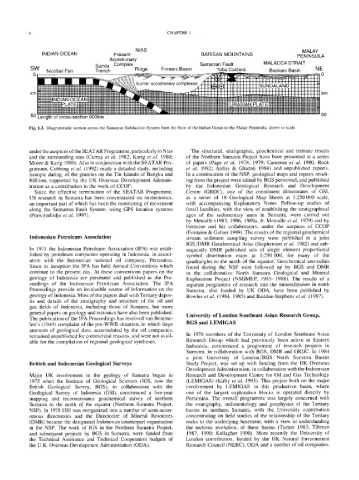
50 Length of cross-section 800kin 50
Fig. 1.3. Diagrammatic section across the Sumatran Subduction System from the floor of the Indian Ocean to the Malay Peninsula, drawn to scale.
under the auspices of the SEATAR Programme, particularly in Nias The structural, stratigraphic, geochemical and tectonic results
and the surrounding seas (Curray et al. 1982; Karig et al. 1980; of the Northern Sumatra Project have been presented in a series
Moore & Karig 1980). Also in conjunction with the SEATAR Pro- of papers (Page et al. 1978, 1979; Cameron et al. 1980; Rock
gramme, Cobbing et al. (1992) made a detailed study, including et al. 1982; Aldiss & Ghazali 1984) and unpublished reports.
isotopic dating, of the granites on the Tin Islands of Bangka and In a continuation of the NSP, geological maps and reports result-
Billiton, supported by the UK Overseas Development Adminis- ing from the project were edited by BGS personnel, and published
tration as a contribution to the work of :COP. by the Indonesian Geological Research and Development
Since the effective termination of the SEATAR Programme, Centre (GRDC), one of the constituent directorates of GSI,
US research in Sumatra has been concentrated on neotectonics, as a series of 18 Geological Map Sheets at 1:250 000 scale,
an important part of which has been the monitoring of movement with accompanying Explanatory Notes. Follow-up studies of
along the Sumatran Fault System, using GPS location systems fossil localities, with the view of establishing the stratigraphical
(Prawirodirdjo et al. 1997). ages of the sedimentary units in Sumatra, were carried out
by Metcalfe (1983, 1986, 1989a, b; Metcalfe et al. 1979) and by
Fontaine and his collaborators, under the auspices of :COP
(Fontaine & Gafoer 1989). The results of the regional geochemical
Indonesian Petroleum Association stream sediment sampling survey were published in a joint
IGS/DMR Geochemical Atlas (Stephenson et al. 1982) and sub-
In 1971 the Indonesian Petroleum Association (IPA) was estab- sequently DMR published sets of single element proportional
lished by petroleum companies operating in Indonesia, in associ- symbol distribution maps at 1:250000, for many of the
ation with the Indonesian national oil company, Pertamina. quadrangles to the north of the equator. Geochemical anomalies
Since its inception the IPA has held Annual Conventions which found during the NSP were followed up by BGS and DMR
continue to the present day. At these conventions papers on the in the collaborative North Sumatra Geological and Mineral
geology of Indonesia are presented and published as the Pro- Exploration Project (NSGMEP, 1985-1988). The results of a
ceedings of the Indonesian Petroleum Association. The IPA separate programme of research into the mineralization in north
Proceedings provide an invaluable source of information on the Sumatra, also funded by UK ODA, have been published by
geology of Indonesia. Most of the papers deal with Tertiary depos- Bowles et al. (1984, 1985) and Beddoe-Stephens et al. (1987).
its and details of the stratigraphy and structure of the oil and
gas fields of Indonesia, including those of Sumatra, but more
general papers on geology and tectonics have also been published. University of London Southeast Asian Research Group,
The publication of the IPA Proceedings has resolved van Bemme-
len's (1949) complaint of the pre-WWII situation, in which large BGS and LEMIGAS
amounts of geological data, accumulated by the oil companies,
remained unpublished for commercial reasons, and were not avail- In 1978 members of the University of London Southeast Asian
able for the compilation of regional geological syntheses. Research Group which had previously been active in Eastern
Indonesia, commenced a programme of research projects in
Sumatra, in collaboration with BGS, DMR and GRDC. In 1984
a joint University of London/BGS North Sumatra Basins
British and Indonesian Geological Surveys Study Project, was set up with funding from the UK Overseas
Development Administration, in collaboration with the Indonesian
Major UK involvement in the geology of Sumatra began in Research and Development Centre for Oil and Gas Technology
1975 when the Institute of Geological Sciences (IGS, now the (LEMIGAS) (Kirby et al. 1993). This project built on the major
British Geological Survey, BGS), in collaboration with the involvement by LEMIGAS in this productive basin, where
Geological Survey of Indonesia (GSI), commenced a five-year one of the largest exploration blocks is operated directly by
mapping and reconnaissance geochemical survey of northern Pertamina. The overall programme was largely concerned with
Sumatra to the north of the equator (Northern Sumatra Project, the stratigraphy, sedimentology and geophysics of the Tertiary
NSP). In 1978 GSI was reorganized into a number of semi-auton- basins in northern Sumatra, with the University contribution
omous directorates and the Directorate of Mineral Resources Concentrating on field studies of the relationship of the Tertiary
(DMR) became the designated Indonesian counterpart organisation rocks to the underlying basement, with a view to understanding
in the NSP. The work of IGS in the Northern Sumatra Project, the tectonic evolution, of these basins (Turner 1983; Tiltman
and subsequent projects by BGS in Sumatra, were funded from 1987, 1990; Kallagher 1990). More recently the University of
the Technical Assistance and Technical Cooperation budgets of London contribution, funded by the UK Natural Environment
the U.K. Overseas Development Administration (ODA). Research Council (NERC), ODA and a number of oil companies,