
Page 24 - The Petroleum System From Source to Trap
P. 24
16 Magoon and Dow
EXAMPLES OF PETROLEUM SYSTEMS
One way to better understand what is meant by a
petroleum system is to categorize or classify as many
systems as possible. Magoon ( 1 989b) classified
petroleum systems in the United States based on the
complexity of the overburden rock (purebred versus
hybrid), reservoir lithology (siliciclastic versus
carbonate), and kerogen type (type I, II, and ill kerogen).
Later, these same petroleum systems were classified
according to the age of their source rock (Magoon,
1992b). Demaison and Huizinga (1991; Chapter 4, this
volume) classified 38 petroleum systems found
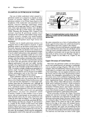
throughout the world by hydrocarbon charge (super Figure 1.6. An atypical petroleum system whose oil origi
charged, normally charged, and undercharged), nates from a source rock that is thermally matured by an
igneous dike.
migration drainage style (vertically versus laterally
drained), and entrapment style (high versus low
impedance).
Another way to classify petroleum syste-ms is to the same composition as a halo of hydrocarbons that
designate them as either typical or atypical. A typical encase a pod of active source rock, which also should be
mapped (Peters and Cassa, Chapter 5, this volume).
petroleum system is an oil system whose source rock is A corollary to the area with stacked or multiple active
thermally matured during deep burial by the over source rocks that form more than one petroleum system
burden rock. Most the case studies in this volume are of is the one source rock that extends over a wide area and
typical petroleum systems. An atypical petroleum system has sufficient overburden rock in more than one area to
is one in which hydrocarbons were generated in other form pods of active source rock (Klemme, Chapter 3;
ways. For example, a petroleum system can occur when Buitrago, Chapter 30; and Mello et al., Chapter 31, this
an immature source rock within a thin sequence of sedi volume).
mentary rocks that overlays continental crust is intruded
by a dike (Figure 1.6). The dike's heat thermally matures Upper Devonian of United States
the source rock and generates oil that seeps into the
adjacent sedimentary rock and river valley. Another More than one petroleum system can form when a
example is the oil generated from the heat related to the source rock extends beyond one package of overburden
ridge vent in the Escanaba trough (Kvenvolden et al., rock to another package (Figures 1 . 88 and 1 . 9). For
1988). Yet another example is biogenic gas generated at a example, when the sedimentary basin of a source rock is
shallow depth through biological activity (Whiticar, on the scale of a continent, such as the Upper Devonian
Chapter 16, this volume), such as the gas in the shallow of the United States, that one organic-rich interval can be
Tertiary sedimentary rock in the Cook Inlet, Alaska the source rock for more than one petroleum system.
(Claypool et. al, 1980; Chapter 22, this volume). However, the stratigraphic nomenclature for this Upper
Typical petroleum systems are shown on Figures 1 . 7 Devonian source rock is different depending on the
and 1 . 8 using maps and cross sections that are each location (in parentheses): Ohio Shale and Devonian black
drawn at the critical moment. Notice that the source rock shale (Appalachian basin), Antrim Shale (Michigan
in each case has been deposited in a much larger sedi basin), New Albany Shale (Illinois basin), Woodford
mentary basin than the overburden rock. Although all Shale (mid-Continent provinces), Aneth Formation
the essential elements and a trap are included in Figure (Paradox basin), Pilot Shale (Great Basin), Bakken
1 . 7 A, a petroleum system is absent because hydrocar Formation (Williston basin), and Exshaw Formation
bons have not been generated. Given the same situation (Sweetgrass arch). Wherever this Upper Devonian
in Figure 1 . 78 but with a source rock now generating source rock is buried enough by overburden rock (basin)
hydrocarbons, you have one petroleum system to generate hydrocarbons, a petroleum system exists.
(Cornford, Chapter 33, this volume). If two or more What eventually matures the Upper Devonian
source rocks are superimposed on one another and are organic-rich interval is increased heat from additional
both thermally mature by the same overburden rock burial by overburden rock deposited in smaller post
within the same basin fill (Figure 1 . 7C), then more than Devonian sedimentary basins (successor basins) located
one petroleum system occurs in the same basin fill (Dow, on or along the edge of the North American craton. Sedi
1972; Talukdar and Marcano, Chapter 29, and Kockel et mentary basins on the craton are sags or rifts, whereas
al., Chapter 34, this volume). If each source rock expels basins at the edge of the craton are foreland basins.
hydrocarbons with unique compositions, then an Unless the sediments are created in situ (e.g., carbonate
analysis of these hydrocarbons from seeps or accumula rocks, evaporites, and coals), the provenance for the
tions will indicate how many systems are in the area. At sediments deposited in all three basin types is the craton
this point, the investigator should map the stratigraphic (as well as the fold-and-thrust belt for the foreland basin).
and geographic extent of the seeps and accumulations of The reservoir and seal rocks are either in the Upper