
Page 69 - Moving the Earth_ The Workbook of Excavation
P. 69
SURVEYS AND MEASUREMENTS
SURVEYS AND MEASUREMENTS 2.19
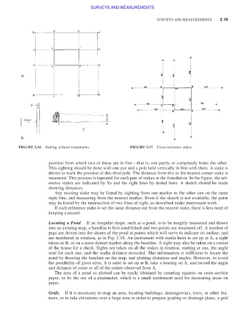
FIGURE 2.16 Staking without instruments. FIGURE 2.17 Cross-reference stakes.
position from which two of these are in line—that is, one partly or completely hides the other.
This sighting should be done with one eye and a pole held vertically in line with them. A stake is
driven to mark the position of this third pole. The distance from this to the nearest corner stake is
measured. This process is repeated for each pair of stakes at the foundation. In the figure, the ref-
erence stakes are indicated by Xs and the sight lines by dotted lines. A sketch should be made
showing distances.
Any missing stake may be found by sighting from one marker to the other one on the same
sight line, and measuring from the nearest marker. Even if the sketch is not available, the point
may be found by the intersection of two lines of sight, as described under instrument work.
If each reference stake is set the same distance out from the nearest stake, there is less need of
keeping a record.
Locating a Pond. If an irregular shape, such as a pond, is to be roughly measured and drawn
into an existing map, a baseline is first established and two points are measured off. A number of
pegs are driven into the shores of the pond at points which will serve to indicate its outline, and
are numbered in rotation, as in Fig. 2.18. An instrument with stadia hairs is set up at A, a sight
taken on B, or on a more distant marker along the baseline. A sight may also be taken on a corner
of the house for a check. Sights are taken on all the stakes in rotation, starting at one, the angle
read for each one, and the stadia distance recorded. This information is sufficient to locate the
pond by drawing the baseline on the map, and plotting distances and angles. However, to avoid
the possibility of gross error, it is safer to set up at B, take a bearing on A, and record the angle
and distance of some or all of the points observed from A.
The area of a pond so plotted can be easily obtained by counting squares on cross-section
paper, or by the use of a planimeter, which is a small instrument used for measuring areas on
paper.
Grids. If it is necessary to map an area, locating buildings, drainageways, trees, or other fea-
tures, or to take elevations over a large area in order to prepare grading or drainage plans, a grid