
Page 25 - Acquisition and Processing of Marine Seismic Data
P. 25
16 1. INTRODUCTION
transmission. Each emitted beam is also per- beams at both sides of the tow-fish. The maxi-
ceived by the transducers during the recording, mum recording distance is termed the sonar
and forms an extremely high-amplitude input at range. The distances are normally measured
the zero time, called the output signal. Then the along a slanted range from the transducers
beams start to travel at both sides of the tow-fish and do not correspond to horizontal distances,
away from the transducers. The first meaningful but can be converted into horizontal distances
return is generally from the seafloor close to the after a specific correction, termed the slant-
tow-fish. Since the travel of the signal to and range correction.
from the seafloor will take some time, depend- The returned signal to the sonar tow-fish is
ing on the tow-fish altitude, and since almost termed backscatter, notthe reflection, and is com-
no signal amplitude is transmitted in a vertical posed of backscattered energy because of the
direction due to the directional pattern of the roughness of the sediment particles on the sea-
emitted signal, there will be a blank zone floor. This roughness acts as a diffractor, which
between the output signal and the seabed scatters the energy in all directions, including
return, which corresponds to the time span for the tow-fish direction. Most of the emitted energy
the sonar signal to travel through the water col- from the transducers is reflected away from the
umn to the seafloor and back to the tow-fish. tow-fish direction, since the reflection angle
This blank zone is indicated by the water col- equals to the incidence angle. However, there
umn in Fig. 1.10. Subsequent to this blank (and will always be some amount of backscattered
in most cases, amplitude free) zone, the seafloor energy, which returns to the tow-fish, is per-
return will arrive at the transducers. After that, ceived by the transducers, and is recorded by
returns from progressively distal ranges of the the sonar recording unit. The amplitude of the
seafloor are successively received by the trans- backscatter is the main information received
ducers. Returned amplitudes are recorded into and recorded by the sonar system, and is used
the disk files starting from time zero to the to discriminate different types of seafloor sedi-
end of the recording for both sides, after convert- ments, since the backscatter amplitudes (in addi-
ing their arrival time to one-way distance from tion to the seafloor topography) are directly
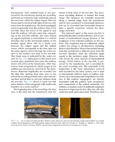
the tow-fish. Fig. 1.11 shows a sonar tow-fish associated with the particle sizes (roughness)
and a shallow water sonograph with small-scale and composition of the seabed sediments. For
boulders on a sandy seafloor. instance, a common order of sediment roughness
The beginning time of the recording, the time from low to high may be clay, silty clay, silt, silty
zero, is the time that the transducers emit the sand, fine sand, and coarse sand. Therefore, each
FIG. 1.11 (A) A sonar tow-fish and (B) a shallow water side-scan sonar record showing small-scale boulders on a sandy
€
˘
seafloor. Sonar frequency is 455 kHz and the range is 50 m per side. Data is from Ozdaş, H., Kızıldag, N., Baydan, C., 2016. Ship-
wreck Inventory Project of Turkey (SHIPT), Special Project Supported by Ministry of Development of Turkey.