
Page 21 - Acquisition and Processing of Marine Seismic Data
P. 21
12 1. INTRODUCTION
converts them into an electric signal for subse- Single-beam echosounders emit only one ver-
quent processing and plotting. tical beam toward the seafloor and use the
The most important acquisition parameter for arrival time of the beam to calculate the water
such high-resolution marine geophysical sys- depth profile just beneath the keel along the ves-
tems is the signal frequency. The resolution sel route. Fig. 1.7A schematically illustrates the
power and penetration depth of these different beam used in single-beam echosounders.
types of acoustic methods strongly depend on A conventional single-beam echosounder
the signal frequency they employ. Even though records the travel time of a beam originated
their penetration depths are limited, the systems from a hull-mounted transducer, and generally
that use higher frequency signals generally pro- a single averaged water column velocity is used
vide higher resolution data for the same seafloor to convert arrival time of the beam into the water
morphology and subsurface sediments than that depth. The same transducer used to generate the
of low-frequency systems. acoustic signal is also used to receive the
returned echo. In analog recorders, calculated
water depth is plotted on a thermal printer after
1.2.1 Bathymetric Systems
amplification, or digitally recorded into the
Acoustic systems used to measure the depth of disks in digital systems.
the oceans (bathymetry) are known as echosoun- Multibeam echosounders are state-of-the-art
dersystems.Measurementofbathymetryisoneof bathymetric systems that utilize more than one
the fundamental offshore observations and is beam to map not only the depth below the keel,
required during installations of offshore plat- but also the bathymetry along both sides of the
forms (even temporary ones) and submarine vessel. They use several beams for a single swath
pipelines, as well as for offshore excavation stud- emitted at different angles from the transducers,
ies. Water depth can also be used in seismic data termed a ping. Fig. 1.7B schematically illustrates
processing by some specific multiple suppression the beams used in multibeam echosounders and
techniques to eliminate the multiple reflections. the example data obtained. Modern multibeam
Echosounders can be classified as single-beam echosounders employ more than 500 beams per
and multibeam systems depending on the ping, which constitute a fan-shaped sweep area
number of acoustic beams they utilize. Table 1.3 extending to both sides of the vessel. Fig. 1.8A
shows the general specifications of both systems. schematically shows the beams, pings and the
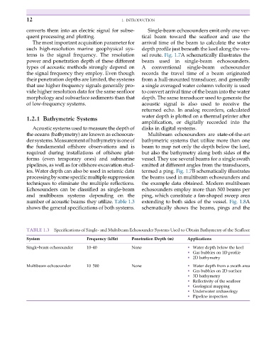
TABLE 1.3 Specifications of Single- and Multibeam Echosounder Systems Used to Obtain Bathymetry of the Seafloor
System Frequency (kHz) Penetration Depth (m) Applications
Single-beam echosounder 10–40 None • Water depth below the keel
• Gas bubbles on 1D profile
• 2D bathymetry
Multibeam echosounder 10–500 None • Water depth from a swath area
• Gas bubbles on 2D surface
• 3D bathymetry
• Reflectivity of the seafloor
• Geological mapping
• Underwater archaeology
• Pipeline inspection