
Page 19 - Acquisition and Processing of Marine Seismic Data
P. 19
10 1. INTRODUCTION
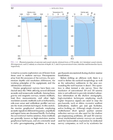
FIG. 1.6 Physical properties of seawater and sound velocity obtained from a CTD profile. (A) Calculated sound velocity,
(B) temperature, and (C) salinity as a function of depth. M, T, and H represent mixed water, halocline and thermocline layers,
respectively.
in marine acoustic exploration are different from geo-hazards encountered during shallow marine
those used in onshore surveys. Discrepancies installations.
arise from the purposes of the surveys, the pen- Before drilling an offshore well, there is a
etration depths and resolution differences, the need to define the surficial morphology as well
working principles of the equipment, and the as the subsurface sediments in the area sur-
information obtained. rounding the well location in detail. This opera-
Marine geophysical surveys have been con- tion is often termed a site survey. Since the
ducted since the 1960s utilizing several different resolution of conventional 2D and 3D seismic
acoustic and nonacoustic methods. Among these, data is not sufficient to provide detailed subsur-
gravity and magnetic surveys, seismic methods, face information on the shallow stratigraphy,
heat flow measurements, and other high- high-resolution techniques employing much
resolution acoustic methods such as bathymetric, higher frequency signals are used to map the
side-scan sonar and subbottom profiler surveys geo-hazards, such as slides, excessive seafloor
are the most common techniques. In this section, inclinations, shallow gas and gas hydrates,
the marine geophysical methods employing active faulting, etc. Although single channel or
acoustic signals in different frequency, amplitude multichannel short spread sparker seismic
and signal forms are discussed briefly. Excluding reflection surveys are also used for the shallow
the conventional marine seismics, these methods geo-engineering problems, 2D and 3D conven-
are generally known as high-resolution marine tional multichannel seismic surveys are mostly
geophysical techniques, and are commonly used used for hydrocarbon exploration by dedicated
to solve geo-engineering problems or to map survey companies, as well as by academia for