
Page 257 - Acquisition and Processing of Marine Seismic Data
P. 257
248 5. PREPROCESSING
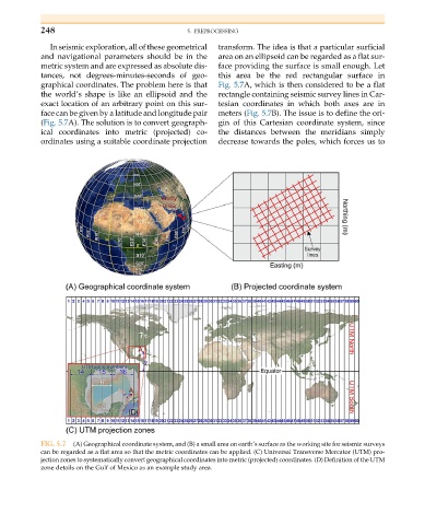
In seismic exploration, all of these geometrical transform. The idea is that a particular surficial
and navigational parameters should be in the area on an ellipsoid can be regarded as a flat sur-
metric system and are expressed as absolute dis- face providing the surface is small enough. Let
tances, not degrees-minutes-seconds of geo- this area be the red rectangular surface in
graphical coordinates. The problem here is that Fig. 5.7A, which is then considered to be a flat
the world’s shape is like an ellipsoid and the rectangle containing seismic survey lines in Car-
exact location of an arbitrary point on this sur- tesian coordinates in which both axes are in
face can be given by a latitude and longitude pair meters (Fig. 5.7B). The issue is to define the ori-
(Fig. 5.7A). The solution is to convert geograph- gin of this Cartesian coordinate system, since
ical coordinates into metric (projected) co- the distances between the meridians simply
ordinates using a suitable coordinate projection decrease towards the poles, which forces us to
FIG. 5.7 (A) Geographical coordinate system, and (B) a small area on earth’s surface as the working site for seismic surveys
can be regarded as a flat area so that the metric coordinates can be applied. (C) Universal Transverse Mercator (UTM) pro-
jection zones to systematically convert geographical coordinates into metric (projected) coordinates. (D) Definition of the UTM
zone details on the Gulf of Mexico as an example study area.