
Page 103 - Digital Analysis of Remotely Sensed Imagery
P. 103
74 Cha pte r T w o
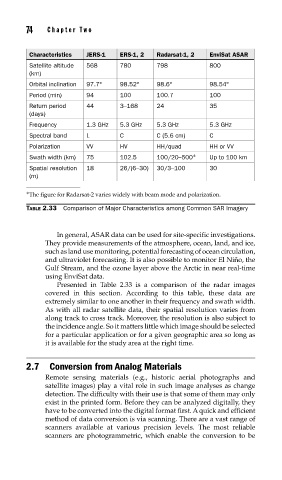
Characteristics JERS-1 ERS-1, 2 Radarsat-1, 2 EnviSat ASAR
Satellite altitude 568 780 798 800
(km)
Orbital inclination 97.7° 98.52° 98.6° 98.54°
Period (min) 94 100 100.7 100
Return period 44 3–168 24 35
(days)
Frequency 1.3 GHz 5.3 GHz 5.3 GHz 5.3 GHz
Spectral band L C C (5.6 cm) C
Polarization VV HV HH/quad HH or VV
Swath width (km) 75 102.5 100/20–500 ∗ Up to 100 km
Spatial resolution 18 26/(6–30) 30/3–100 30
(m)
∗ The figure for Radarsat-2 varies widely with beam mode and polarization.
TABLE 2.33 Comparison of Major Characteristics among Common SAR Imagery
In general, ASAR data can be used for site-specific investigations.
They provide measurements of the atmosphere, ocean, land, and ice,
such as land use monitoring, potential forecasting of ocean circulation,
and ultraviolet forecasting. It is also possible to monitor El Niño, the
Gulf Stream, and the ozone layer above the Arctic in near real-time
using EnviSat data.
Presented in Table 2.33 is a comparison of the radar images
covered in this section. According to this table, these data are
extremely similar to one another in their frequency and swath width.
As with all radar satellite data, their spatial resolution varies from
along track to cross track. Moreover, the resolution is also subject to
the incidence angle. So it matters little which image should be selected
for a particular application or for a given geographic area so long as
it is available for the study area at the right time.
2.7 Conversion from Analog Materials
Remote sensing materials (e.g., historic aerial photographs and
satellite images) play a vital role in such image analyses as change
detection. The difficulty with their use is that some of them may only
exist in the printed form. Before they can be analyzed digitally, they
have to be converted into the digital format first. A quick and efficient
method of data conversion is via scanning. There are a vast range of
scanners available at various precision levels. The most reliable
scanners are photogrammetric, which enable the conversion to be