
Page 99 - Digital Analysis of Remotely Sensed Imagery
P. 99
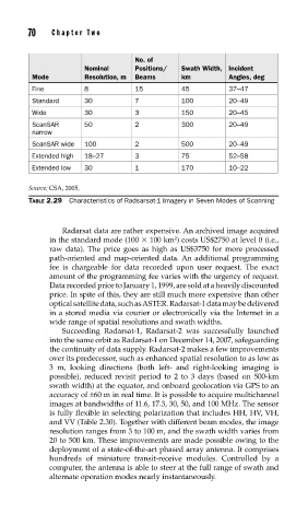
70    Cha pte r  T w o


                                     No. of
                        Nominal      Positions/  Swath Width,  Incident
           Mode         Resolution, m  Beams     km         Angles, deg
           Fine         8            15          45         37–47
           Standard     30           7           100        20–49
           Wide         30           3           150        20–45
           ScanSAR      50           2           300        20–49
           narrow
           ScanSAR wide  100         2           500        20–49
           Extended high  18–27      3           75         52–58
           Extended low  30          1           170        10–22

          Source: CSA, 2005.
          TABLE 2.29  Characteristics of Radsarsat-1 Imagery in Seven Modes of Scanning


                   Radarsat data are rather expensive. An archived image acquired
                                               2
               in the standard mode (100   100 km ) costs US$2750 at level 0 (i.e.,
               raw data). The price goes as high as US$3750 for more processed
               path-oriented and map-oriented data. An additional programming
               fee is chargeable for data recorded upon user request. The exact
               amount of the programming fee varies with the urgency of request.
               Data recorded prior to January 1, 1999, are sold at a heavily discounted
               price. In spite of this, they are still much more expensive than other
               optical satellite data, such as ASTER. Radarsat-1 data may be delivered
               in a stored media via courier or electronically via the Internet in a
               wide range of spatial resolutions and swath widths.
                   Succeeding Radarsat-1, Radarsat-2 was successfully launched
               into the same orbit as Radarsat-1 on December 14, 2007, safeguarding
               the continuity of data supply. Radarsat-2 makes a few improvements
               over its predecessor, such as enhanced spatial resolution to as low as
               3 m, looking directions (both left- and right-looking imaging is
               possible), reduced revisit period to 2 to 3 days (based on 500-km
               swath width) at the equator, and onboard geolocation via GPS to an
               accuracy of ±60 m in real time. It is possible to acquire multichannel
               images at bandwidths of 11.6, 17.3, 30, 50, and 100 MHz. The sensor
               is fully flexible in selecting polarization that includes HH, HV, VH,
               and VV (Table 2.30). Together with different beam modes, the image
               resolution ranges from 3 to 100 m, and the swath width varies from
               20 to 500 km. These improvements are made possible owing to the
               deployment of a state-of-the-art phased array antenna. It comprises
               hundreds of miniature transit-receive modules. Controlled by a
               computer, the antenna is able to steer at the full range of swath and
               alternate operation modes nearly instantaneously.