
Page 95 - Digital Analysis of Remotely Sensed Imagery
P. 95
66 Cha pte r T w o
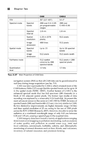
CASI CASI-2
FOV 35° (15°–60°) 54.4°
Spectral mode Spectral 288 over 0.4–0.95 288 over
bands μm programmable 0.405–0.95
ranges
Spectral 1.8 nm 1.8 nm
interval
Spatial 1.23 m (578 512 pixels
resolution pixels)
Image 489 lines 512 pixels
dimension
Spatial mode Spectral Up to 15 Up to 18 spectral
bands bands
Image 512 pixels 512 pixels swath
dimension
Full-frame mode 512 spatial 512 pixels × 288
columns by 288 spectral pixels
spectral bands
Quantization 12 bits 12 bits
level
TABLE 2.27 Main Properties of CASI Data
navigation system (INS) so that all CASI data can be georeferenced in
real time during image acquisition (see Sec. 5.9).
CASI was later superseded by CASI-2, which retained most of the
CASI features (Table 2.27) except that the spectral bands can be up to 18
in the spatial mode (NERC ARSF). Another feature of CASI-2 is the
enhanced spectral mode that has full spectrum (288 channels) in a
block of 101 adjacent spatial pixels. The former tape media of data
recording was replaced by a removable 9 Gb hard disk. At present the
most advanced sensor in this series is CASI 1500 by ITRES. In terms of
spectral bands (288) and bandwidth (2.2 nm), it is very similar to CASI.
Its two distinctive improvements are higher dynamic range (14 bits)
and finer spatial resolution of 25 cm owing to the use of 1500 pixels
across the FOV (ITRES Research, 2007). However, it is able to sense the
radiation at a combined wavelength range of only 0.65 μm between
0.38 and 1.05 μm, causing a spectral gap in the acquired data.
CASI imagery data have found a variety of applications ranging
from forest cover mapping to pollution monitoring, such as analysis
of water quality and pollution in coastal areas (e.g., total and
fecal coliforms, aeromonads, turbidity, salinity, and chlorophyll);
monitoring of natural disasters such as fires, floods, and volcanoes;
inventory of natural resources; and precision farming.