
Page 100 - Digital Analysis of Remotely Sensed Imagery
P. 100
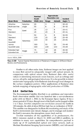
Overview of Remotely Sensed Data       71


                                                 Approximate
                                    Nominal
                                                Resolution (m)
                                    Swath                      Incident
           Beam Mode    Polarization  Width (km)  Range  Azimuth  Angle (°)
           Ultra-fine   Selective   20        3       3        30–40
           Multi-look fine  single  50        8       8        30–50
           Fine                     25        12      8        20–41
                        Quad
           Standard                 25        25      8        20–41
           Fine                     50        8       8        30–50
           Standard                 100       25      26       20–49
           Wide                     150       30      26       20–45
                        Selectives
           ScanSAR
           narrow                   300       50      50       20–46
           ScanSAR wide             500       100     100      20–49
           Extended high            75        18      26       49–60
                        Single
           Extended low             170       40      26       10–23

          Source: MDA, 2008.
          TABLE 2.30  Typical Spatial Resolutions of Radarsat-2 Imagery in Different Beam
          Modes and Polarizations


                   Similar to all other radar data, Radarsat images are best applied
               to areas that cannot be adequately imaged with optical sensors. In
               comparison with optical sensor data, Radarsat data offer useful
               values in identifying mesoscale ocean features, such as icebergs and
               sea ice, oil spills, and geological structures. It is also possible to detect
               underwater topography from Radarsat data through local changes in
               the surface roughness pattern. Other applications of Radarsat data
               include mapping of topographic relief and production of DEMs.

               2.6.4 EnviSat Data
               The Environmental Satellite (EnviSat) is an ambitious and innovative
               Earth observation satellite that was launched into a sun-synchronous
               polar orbit on March 1, 2002, by the European Space Agency. It has a
               return period of 35 days, though most of the Earth can be imaged within
               1 to 3 days. EnviSat completes one revolution around the Earth in
               100 minutes. Its orbit of about 800 km high has an inclination of 98.54°.
               This satellite was designed to facilitate the monitoring and study of the
               Earth’s environment and climate changes, and to manage and monitor
               the Earth’s resources, the atmosphere, ocean, land, and ice.
                   EnviSat maintains all the capabilities of its predecessors, the
               ERS-1 (mission ended on March 10, 2000) and ERS-2 satellites, in
               addition to many new capabilities. Its comprehensive payload is
               made up of 10 sophisticated optical and radar sensors, such as
               Medium Resolution Imaging Spectrometer (MERIS), and Advanced