
Page 98 - Digital Analysis of Remotely Sensed Imagery
P. 98
Overview of Remotely Sensed Data 69
H
Nadir path
23∞
Scanned area
250 km
100 km
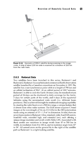
FIGURE 2.11 Geometry of ERS-1 satellite during scanning in the image
mode. A strip of about 100 km wide is scanned at a distance of 250 km
from the nadir track.
2.6.3 Radarsat Data
Two satellites have been launched in this series, Radarsat-1 and
Radarsat-2. Radarsat-1 is a sophisticated commercial Earth observation
satellite launched by a Canadian consortium on November 4, 1995. The
satellite has a sun-synchronous polar orbit at a height of 798 km and
an orbital inclination of 98.6°. At an orbital period of 100.7 minutes,
Radarsat-1 is able to circle the Earth 14 times a day. Its standard return
period of 24 days can be shortened to daily coverage for the Arctic,
3 days for certain parts of the world, and 6 days at the equatorial
latitudes using the nonstandard wide swath (i.e., different beam
positions). This is achieved through the multimode imaging capability
by steering the radar beam over a 500-km range, a unique feature that
is absent from other radar systems. The SAR sensor acquires C-band
images at the wavelength of 5.6 cm (5.3 GHz) in the HH polarization
mode using an antenna of 15 1.5 m in dimension. In total, there are
2
seven beam modes in Radarsat-1 (fine, standard, wide, ScanSAR narrow,
ScanSAR wide, extended high, and extended low), each offering a
unique image resolution and swath width (Table 2.29). Associated with
these modes are variations in image swath from 45 to 500 km in
width, in resolution from 8 to 100 m, and in incidence angle from 10°
to 58°. All sensed areas on the ground lie to the right of the satellite
path as Radarsat-1 is a right-looking satellite.