
Page 94 - Digital Analysis of Remotely Sensed Imagery
P. 94
Overview of Remotely Sensed Data 65
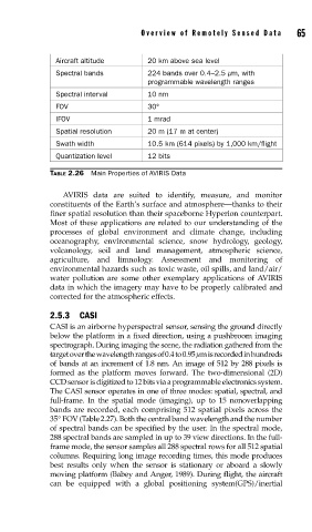
Aircraft altitude 20 km above sea level
Spectral bands 224 bands over 0.4–2.5 μm, with
programmable wavelength ranges
Spectral interval 10 nm
FOV 30°
IFOV 1 mrad
Spatial resolution 20 m (17 m at center)
Swath width 10.5 km (614 pixels) by 1,000 km/flight
Quantization level 12 bits
TABLE 2.26 Main Properties of AVIRIS Data
AVIRIS data are suited to identify, measure, and monitor
constituents of the Earth’s surface and atmosphere—thanks to their
finer spatial resolution than their spaceborne Hyperion counterpart.
Most of these applications are related to our understanding of the
processes of global environment and climate change, including
oceanography, environmental science, snow hydrology, geology,
volcanology, soil and land management, atmospheric science,
agriculture, and limnology. Assessment and monitoring of
environmental hazards such as toxic waste, oil spills, and land/air/
water pollution are some other exemplary applications of AVIRIS
data in which the imagery may have to be properly calibrated and
corrected for the atmospheric effects.
2.5.3 CASI
CASI is an airborne hyperspectral sensor, sensing the ground directly
below the platform in a fixed direction, using a pushbroom imaging
spectrograph. During imaging the scene, the radiation gathered from the
target over the wavelength ranges of 0.4 to 0.95 μm is recorded in hundreds
of bands at an increment of 1.8 nm. An image of 512 by 288 pixels is
formed as the platform moves forward. The two-dimensional (2D)
CCD sensor is digitized to 12 bits via a programmable electronics system.
The CASI sensor operates in one of three modes: spatial, spectral, and
full-frame. In the spatial mode (imaging), up to 15 nonoverlapping
bands are recorded, each comprising 512 spatial pixels across the
35° FOV (Table 2.27). Both the central band wavelength and the number
of spectral bands can be specified by the user. In the spectral mode,
288 spectral bands are sampled in up to 39 view directions. In the full-
frame mode, the sensor samples all 288 spectral rows for all 512 spatial
columns. Requiring long image recording times, this mode produces
best results only when the sensor is stationary or aboard a slowly
moving platform (Babey and Anger, 1989). During flight, the aircraft
can be equipped with a global positioning system(GPS)/inertial