
Page 89 - Digital Analysis of Remotely Sensed Imagery
P. 89
60 Cha pte r T w o
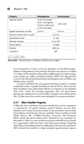
Property Multispectral Panchromatic
Spectral bands 0.45–0.52 (blue)
0.52–0.60 (green)
0.45–0.90
0.625–0.695 (red)
0.76–0.90 (NIR)
Spatial resolution at nadir 1.64 m 0.41 m
Nominal swath width at nadir 15.2 km
Quantization level 11 bits
Off-nadir viewing Up to 60°
Revisit period <3 days
Altitude 684 km
Inclination 98°
Source: GeoEye, 2007b.
TABLE 2.24 Characteristics of GeoEye-1 Satellite and Imagery
its revisit period to 3 days or less for anywhere on the Earth surface.
Objects on the ground can be precisely located to an accuracy of within
3 m. Data will be supplied to the public at different levels of processing,
such as basic, geo, ortho, and stereo (GeoEye, 2007b). It is also possible
to derive elevational information from the imagery, such as DEMs, and
digital surface models.
GeoEye-2 will follow the same general setting as GeoEye-1 except it
is planned to have a spatial resolution as fine as 0.25 m. However, the
final resolution to be determined will have to depend on the feedback
from users. Under the licensing agreement, only U.S. government
agencies are authorized to access GeoEye-2 images at the finest resolu-
tion. Civilian users may receive data resampled to a coarser resolution.
2.4.7 Other Satellite Programs
Unlike the above satellites that were launched by private companies
or consortiums for profit making, except Cartosat, several other
satellites have been launched mostly by governments that include
Israel, Russia, South Korea, Taiwan, and Italy. These satellites include
EROS, Resurs DK, COSMO-SkyMed, Formosat, and Kompsat.
EROS (Earth Resources Observation Satellite)-A was launched on
December 5, 2000, to a sun-synchronous polar orbit 480 km in altitude
by a consortium with close ties to the Israeli government. Weighing
only 250 kg, the satellite started to collect data commercially in January
2001. Aboard the satellite is a high resolution panchromatic camera