
Page 88 - Digital Analysis of Remotely Sensed Imagery
P. 88
Overview of Remotely Sensed Data 59
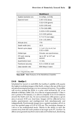
WorldView-2
Spatial resolution (m) 0.5 (Pan), 1.8 XSL
Spectral band 0.45–0.52 (blue)
0.52–0.59 (green)
0.63–0.69 (red)
0.76–0.89 (NIR)
0.423–0.453 (coastal)
0.5–0.64 (yellow)
0.7–0.73 (red edge)
0.9–1.05 (NIR-2)
Altitude (km) 770
Swath width (km) 16.5
Revisit cycle (days) 1.1 at 1.0 m to 4.2 at
0.52 m GSD
Orbital type Circular, sun synchronous
Off-nadir viewing Up to 45° at 4.5° per
capability second
Quantization level 11 bits
Positional accuracy 6.5 m CE90 at nadir
Data transfer rate 800 Mbps X band
Source: DigitalGlobe, 2008.
TABLE 2.23 Main Features of the WorldView-2 Satellite
2.4.6 GeoEye-1
Scheduled for launch in mid-2008, the GeoEye-1 satellite will acquire
the highest resolution images of the Earth, owing to the use of the most
advanced sensing technology ever in a commercial system. The satellite
will revolve around the Earth in a polar orbit inclined by 98° at an
altitude of 684 km (Table 2.24). At a velocity of approximately 7.5 km/s
and a period of 98 minutes, it is able to complete 12 to 13 revolutions
around the Earth each day. Its sun-synchronous orbit passes a given
area at around 10:30 a.m. local time. Images will be collected in two
modes, panchromatic and multispectral, both simultaneously and
independently. Panchromatic images have a spatial resolution of 0.41 m
over the spectral range of 0.45 to 0.90 μm. The resolution changes to
1.64 m in the multispectral mode. Thanks to the ability to steer the
camera away from the nadir position at an angle up to 35°, GeoEye-1 is
able to sense ground areas from side to side and front to back, shortening