
Page 84 - Digital Analysis of Remotely Sensed Imagery
P. 84
Overview of Remotely Sensed Data 55
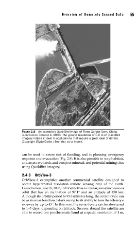
FIGURE 2.9 An exemplary QuickBird image of Three Gorges Dam, China,
recorded on October 4, 2003. The ground resolution of 0.6 m of QuickBird
imagery makes it ideal in applications that require a great deal of details.
(Copyright DigitalGlobe.) See also color insert.
can be used to assess risk of flooding, and in planning emergency
response and evacuation (Fig. 2.9). It is also possible to map habitats,
and assess wetlands and prospect minerals and potential mining sites
using QuickBird imagery.
2.4.3 OrbView-3
OrbView-3 exemplifies another commercial satellite designed to
obtain hyperspatial resolution remote sensing data of the Earth.
Launched on June 26, 2003, OrbView-3 has a circular, sun-synchronous
orbit that has an inclination of 97.1° and an altitude of 450 km.
Although its orbital period is 93.6 minutes long, the revisit cycle can
be as short as less than 3 days owing to its ability to turn the telescope
sideway by up to 45°. In this way, the revisit cycle can be shortened
to 1–5 days, depending on latitude. Sensors aboard the satellite are
able to record one panchromatic band at a spatial resolution of 1 m,