
Page 85 - Digital Analysis of Remotely Sensed Imagery
P. 85
56 Cha pte r T w o
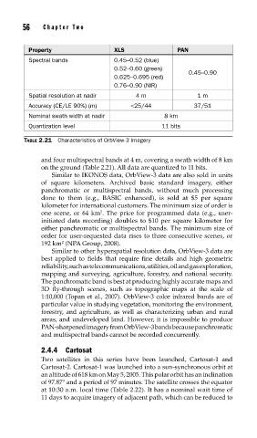
Property XLS PAN
Spectral bands 0.45–0.52 (blue)
0.52–0.60 (green)
0.45–0.90
0.625–0.695 (red)
0.76–0.90 (NIR)
Spatial resolution at nadir 4 m 1 m
Accuracy (CE/LE 90%) (m) <25/44 37/51
Nominal swath width at nadir 8 km
Quantization level 11 bits
TABLE 2.21 Characteristics of OrbView-3 Imagery
and four multispectral bands at 4 m, covering a swath width of 8 km
on the ground (Table 2.21). All data are quantized to 11 bits.
Similar to IKONOS data, OrbView-3 data are also sold in units
of square kilometers. Archived basic standard imagery, either
panchromatic or multispectral bands, without much processing
done to them (e.g., BASIC enhanced), is sold at $5 per square
kilometer for international customers. The minimum size of order is
2
one scene, or 64 km . The price for programmed data (e.g., user-
initiated data recording) doubles to $10 per square kilometer for
either panchromatic or multispectral bands. The minimum size of
order for user-requested data rises to three consecutive scenes, or
2
192 km (NPA Group, 2008).
Similar to other hyperspatial resolution data, OrbView-3 data are
best applied to fields that require fine details and high geometric
reliability, such as telecommunications, utilities, oil and gas exploration,
mapping and surveying, agriculture, forestry, and national security.
The panchromatic band is best at producing highly accurate maps and
3D fly-through scenes, such as topographic maps at the scale of
1:10,000 (Topan et al., 2007). OrbView-3 color infrared bands are of
particular value in studying vegetation, monitoring the environment,
forestry, and agriculture, as well as characterizing urban and rural
areas, and undeveloped land. However, it is impossible to produce
PAN-sharpened imagery from OrbView-3 bands because panchromatic
and multispectral bands cannot be recorded concurrently.
2.4.4 Cartosat
Two satellites in this series have been launched, Cartosat-1 and
Cartosat-2. Cartosat-1 was launched into a sun-synchronous orbit at
an altitude of 618 km on May 5, 2005. This polar orbit has an inclination
of 97.87° and a period of 97 minutes. The satellite crosses the equator
at 10:30 a.m. local time (Table 2.22). It has a nominal wait time of
11 days to acquire imagery of adjacent path, which can be reduced to