
Page 80 - Digital Analysis of Remotely Sensed Imagery
P. 80
Overview of Remotely Sensed Data 51
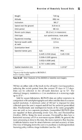
Weight 720 kg
Altitude 681 km
Inclination 98.1°
Speed over the ground 6.8 km/s
Orbit period 98 min
Revisit cycle (days) 35 (3 at 1 m resolution)
Orbit type sun synchronous, near polar
Equatorial crossing 10:30 a.m.
Nominal swath width 13 km
at nadir
Quantization level 11 bits
Spectral bands (μm) XLS PAN
0.445–0.516 (blue) 0.45–0.90
0.506–0.595 (green)
0.632–0.698 (red)
0.757–0.853 (NIR)
Spatial resolution (m) 4 1 (0.5) ∗
∗ Figure in the bracket applies to IKONOS-3.
Source: GeoEye, 2007a.
TABLE 2.19 Main Features of the IKONOS-2 Satellite and Imagery
700 km on either side of the track in the off-nadir viewing position,
reducing the revisit period from the normal 35 days to 1.5 days.
Data can be collected in the off-nadir direction up to 52°. The
obtained imagery maintains a <1-m resolution at a scanning angle
up to 27.1°.
Sold by square kilometers, IKONOS data are rather expensive in
comparison with aerial photographs and other satellite data of a coarser
spatial resolution. A minimum order of 100 km is imposed for data
2
2
collected upon the user’s request and 49 km for archived georectified
data. Panchromatic and multispectral bands of the same geographic
area are sold as two separate products. Georectified IKONOS data
are supplied at three processing levels: Geo, Pro, and PrecisionPlus
(GeoEye, 2007a). Being the most accurate, PrecisionPlus data have a
horizontal accuracy of 0.9 m root-mean-square (RMS). In general, the
more processing is done to the data, the more expensive they become.
A delicate balance must be struck between cost and accuracy of data.
One way of bringing down the cost is to purchase a multiorganization
licensing policy within a large institution (see Sec. 4.8).