
Page 78 - Digital Analysis of Remotely Sensed Imagery
P. 78
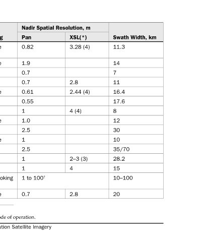
Swath Width, km  11.3  14  7  11  16.4  17.6  8  12  30  10  35/70  28.2  15  10–100  20


          Nadir Spatial Resolution, m  XSL(*)  Pan  3.28 (4)  0.82  1.9  0.7  2.8  0.7  2.44 (4)  0.61  0.55  4 (4)  1.0  2.5  2.5  2–3 (3)  4  1 to 100 †  2.8  0.7


              Viewing  Flexible  Flexible  Flexible  1  Flexible  +26°  1 Flexible  ±24°  1  1  Side looking  Flexible


              Altitude, km  680  600  500  500  450  496  470  565  617  630  691  360–604  675–701  622–627  694 † ASI-Italy Space Agency/Ministry of Defense. Resolution depends on the mode of operation. A Comparison of Major Characteristics of Very High Resolution Satellite Imagery


                 GeoEye(Space   ImageSat Int Israel  DigitalGlobe  DigitalGlobe  NASDA, Japan  CNES, France

              Agency  Imaging)       OrbImage  ISRO, India  ISRO, India  Russia  Korea  ASI/MOD


              Satellite  IKONOS 2/3  EROS A  EROS B  EROS C  QuickBird 2/3  WorldView 1/2  OrbView X  TESS  Cartosat- 1  Cartosat- 2  ALOS  Resurs DK1- 3  Kompsat- 2  COSMO-  SkyMed  Pleiades- 1/2  * Number of spectral bands.  TABLE 2.18


                                                                     49