
Page 73 - Digital Analysis of Remotely Sensed Imagery
P. 73
Overview of Remotely Sensed Data 45
request is received. All archived ASTER 1A and 1B data may be
searched and ordered via the Earth Observing System Data Gateway
(EDG) at http://lpdaac.usgs.gov/.
ASTER data are rather inexpensive. Level 1 data of the U.S.
continent and territories can be downloaded from the above site for
free. Data for the rest of the world can be purchased at $85 ($80 plus
$5 handling fee) per scene. Data delivery via the Internet is rather
efficient and quick if the user has access to broadband. At a relatively
high spatial resolution with over 10 spectral bands, ASTER data serve
as a continuation of Landsat TM data. Therefore, their application
areas are highly similar to those of TM data. They include, but are not
restricted to, natural resources mapping and monitoring. In particular,
ASTER VNIR imagery is invaluable in applications where it is
important to monitor sparsely populated vegetation such as land
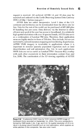
desertification and soil salinization (Fig. 2.6). In such applications
SWIR data are not as useful as Landsat ETM because they overlap
with each other excessively in their information content (Gao and
Liu, 2008). The combination of the 3D viewing capability of ASTER
FIGURE 2.6 A subscene (1001 rows by 1101 columns) ASTER image of
Northeast China recorded on September 11, 2004. This color composite is
formed by VNIR bands 1 (b), 2 (g), and 3 (r). Its spatial resolution of 15 m is
ideal in studying natural hazards such as land salinization, which appears as
white patches in this composite. See also color insert.