
Page 75 - Digital Analysis of Remotely Sensed Imagery
P. 75
Overview of Remotely Sensed Data 47
enhance our understanding of the dynamics and processes of the Earth’s
surface on the global scale, such as global change in oceanography,
biology, and the atmosphere. In particular, MODIS bands 1 to 7 can be
used to differentiate land from cloud and to study the boundaries and
properties of aerosols. Bands 8 to 16 are the most useful in studying
ocean colors, phytoplankton, and biogeochemistry. All the remaining
bands are suited to determine atmospheric water vapor, study surface
and cloud temperature, ozone and cloud, as well as the temperature of
the atmosphere. Therefore, MODIS data are suited not only to the study
of the Earth’s surface, but also the atmosphere.
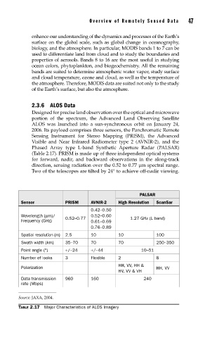
2.3.6 ALOS Data
Designed for precise land observation over the optical and microwave
portion of the spectrum, the Advanced Land Observing Satellite
ALOS was launched into a sun-synchronous orbit on January 24,
2006. Its payload comprises three sensors, the Panchromatic Remote
Sensing Instrument for Stereo Mapping (PRISM), the Advanced
Visible and Near Infrared Radiometer type 2 (AVNIR-2), and the
Phased Array type L-band Synthetic Aperture Radar (PALSAR)
(Table 2.17). PRISM is made up of three independent optical systems
for forward, nadir, and backward observations in the along-track
direction, sensing radiation over the 0.52 to 0.77 μm spectral range.
Two of the telescopes are tilted by 24° to achieve off-nadir viewing.
PALSAR
Sensor PRISM AVNIR-2 High Resolution ScanSar
0.42–0.50
Wavelength (μm)/ 0.52–0.60
0.52–0.77 1.27 GHz (L band)
Frequency (GHz) 0.61–0.69
0.76–0.89
Spatial resolution (m) 2.5 10 10 100
Swath width (km) 35–70 70 70 250–350
Point angle (°) +/−24 +/−44 10–51
Number of looks 3 Flexible 2 8
HH, VV, HH &
Polarization HH, VV
HV, VV & VH
Data transmission 960 160 240
rate (Mbps)
Source: JAXA, 2004.
TABLE 2.17 Major Characteristics of ALOS Imagery