
Page 68 - Digital Analysis of Remotely Sensed Imagery
P. 68
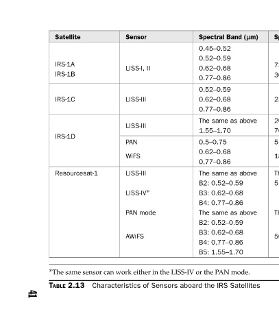
Spectral Band (lm) Quantization Level, bits  Swath Width, km Spatial Resolution, m  0.45–0.52  0.52–0.59  73 (I)  0.62–0.68  7  146  36 (II)  0.77–0.86  0.52–0.59  7  141  23.5 0.62–0.68  0.77–0.86  20 The same as above  148  70.5 1.55–1.70  6  70  5.8 0.5–0.75  0.62–0.68  810  189  0.77–0.86  The


          Sensor  LISS-I, II  LISS-III  LISS-III  PAN  WiFS  LISS-III  LISS-IV ∗  PAN mode  AWiFS ∗ The same sensor can work either in the LISS-IV or the PAN mode.  Characteristics of Sensors aboard the IRS Satellites


          Satellite  IRS-1A  IRS-1B  IRS-1C  IRS-1D  Resourcesat-1   TABLE 2.13


                                                                     41