
Page 63 - Digital Analysis of Remotely Sensed Imagery
P. 63
36 Cha pte r T w o
Image Properties Multispectral Panchromatic
Wavelength (μm) 0.50–0.59 0.51–0.73
0.61–0.68
0.79–0.89
∗
SWIR (shortwave infrared) 1.58–1.75
†
Spatial resolution at nadir (m) 20 10 (2.5 or 5)
Swath width at nadir (km) 60 60
Number of pixels per line 3,000 6,000
Quantization level (bits) 8 6
∗ Available in SPOT 4 and SPOT 5 only.
†
Figure in the bracket applies to SPOT 5 only.
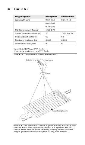
TABLE 2.10 Characteristics of SPOT Satellite Data
Detector array Focal plane
Lens
Scanning
direction
Ground sampling size
Swath width
Satellite motion
FIGURE 2.3 The “pushbroom” concept of ground scanning adopted by SPOT
satellites. In this mode the scanning direction is in agreement with the
satellite motion direction, hence shortening scanning duration to achieve
a higher geometric fi delity at the expense of using more detectors.