
Page 62 - Digital Analysis of Remotely Sensed Imagery
P. 62
Overview of Remotely Sensed Data 35
water resources, monitoring flooding, and in agriculture, geology, and
oceanography. These applications are made more versatile and robust
by a large body of data spanning over three decades.
2.3.2 SPOT Data
Designed by the French Centre National d’Etudes Spatiales (CNES),
SPOT was first launched into an orbit of 832 km on February 21,
1986. This first commercial Earth observation satellite provides
complete world coverage with stereoscopic viewing capability at a
high spatial resolution. A number of satellites have been launched in
this series, all having an identical set of orbital parameters, such as a
circular, near-polar, sun-synchronous orbit with an inclination of
98.7° (Table 2.9).
The payload of the first three SPOT satellites encompasses two
identical high resolution visible (HRV) sensors that operate in either of
two modes, panchromatic or multispectral. In the first mode, one pan-
chromatic band is acquired over the wavelength range of 0.51 to 0.73 μm
at a spatial resolution of 10 m. In the second mode, three multispectral
bands are obtained at a spatial resolution of 20 m (Table 2.10). Unlike
Landsat TM, SPOT uses the pushbroom scanning technology to minimize
scanning duration (Fig. 2.3). Owing to the use of a linear array of 6000
detectors, 3000 lines of imagery in the multispectral mode or 6000 lines
of imagery in the panchromatic mode are obtained simultaneously.
Consequently, SPOT imagery is much more geometrically reliable than
its Landsat counterpart obtained via cross-track scanning. Furthermore,
the scanning mirror can be tilted in steps of 0.6° by up to 27° in either
direction away from the nadir, reaching a maximum swath width of
80 km (Fig. 2.4). This off-nadir viewing capability brings out two
advantages in image acquisition.
First, it can curtail the revisit period of the satellite from the
nominal 26 days to a few days. If the nadir area is under cloud cover,
it can still be sensed during the next orbit of the same day by steering
the scanning mirror sideway toward the missed track on the ground.
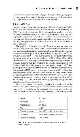
Height 832 km
Inclination 98.7°
Repeat cycle 26 days
FOV 4.14°
Off-nadir viewing Up to 27° in 45 steps of 0.6°
Orbit type Near polar, sun synchronous
Equatorial crossing 10:30 a.m.
TABLE 2.9 Orbital Parameters and Sensor Characteristics of
SPOT Satellites